How SATPALDA Leverages Vantor’s Satellite Tech for Reliable Positioning in GPS- Denied Areas
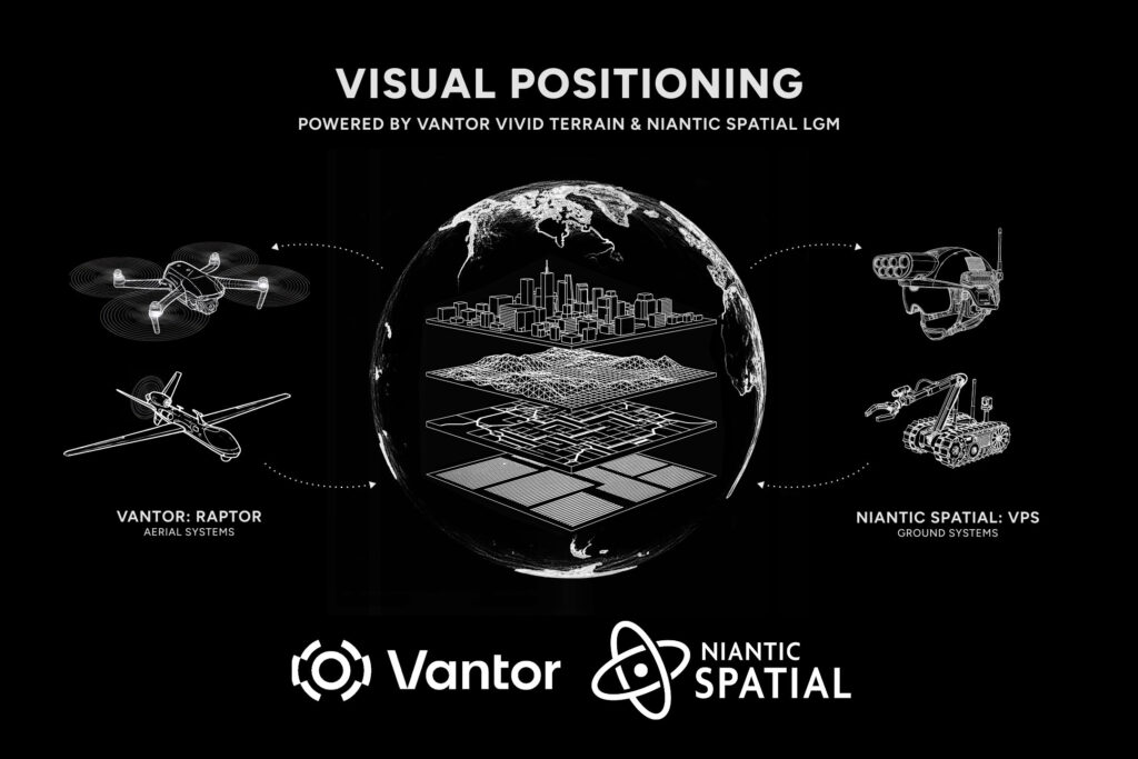
Image Credit: Business Wire
The Real-World Challenge of GPS-Denied Environments
Across urban infrastructure, transportation corridors, critical facilities, and security-sensitive zones, GPS is often assumed to be reliable. In practice, many outdoor environments experience degraded or denied GPS due to dense urban canyons, signal interference, multipath effects, spoofing, or intentional disruption. For government agencies and enterprises, this creates a serious operational gap—accurate positioning is required precisely where GNSS performance is least dependable.
The challenge today is no longer access to satellite navigation signals alone, but the ability to maintain continuous, trustworthy positioning across complex outdoor environments. This is where advanced geospatial technology, satellite imagery, and GIS-based spatial intelligence become essential.
Technology Overview: Niantic Spatial and Vantor
This challenge is being addressed through the combined capabilities of Niantic Spatial and Vantor, two complementary technologies purpose-built for GPS-challenged environments.
Niantic Spatial provides a powerful Visual Positioning System (VPS) that determines precise location and orientation by matching real-time camera inputs—captured from mobile devices, vehicles, or aerial platforms—against large-scale visual maps. Instead of relying solely on GNSS, the system uses the physical environment itself—buildings, road networks, terrain features, and urban landmarks—as positioning references.
Vantor strengthens this capability by delivering high-accuracy satellite-derived spatial reference frameworks. By aligning satellite imagery, aerial observations, and ground-level visual data, Vantor ensures consistent geospatial accuracy across air-to-ground workflows. Together, Niantic Spatial and Vantor enable a unified air-to-ground positioning solution designed specifically for GPS-denied outdoor environments.
Reliable positioning in GPS-denied outdoor environments is becoming critical for modern infrastructure, transportation, and security operations. By integrating Niantic Spatial’s Visual Positioning System with Vantor’s high-accuracy satellite reference data—enabled through Satpalda—organizations can achieve continuous, precise location awareness even where GNSS signals fail. This unified air-to-ground geospatial solution delivers resilient positioning, scalable GIS integration, and enterprise-ready spatial intelligence for complex outdoor environments.
Satpalda’s Role: Enterprise Enablement and Integration
Satpalda plays a critical role in operationalizing this advanced technology stack for real-world deployment. Acting as the enterprise enabler and system integrator, Satpalda brings Niantic Spatial and Vantor capabilities into scalable, commercially viable geospatial workflows.
Through Satpalda, organizations can access these advanced positioning capabilities alongside satellite imagery, GIS data, and spatial analytics within a single, coherent ecosystem. Satpalda ensures seamless compatibility with existing GIS platforms, digital twins, and decision-support systems, significantly reducing adoption friction and accelerating time-to-value.
Technical Strengths Built for Outdoor Operations
The combined solution offers several strengths optimized for large-scale outdoor use.
First, air-to-ground spatial consistency—satellite imagery, aerial data, and ground-level visuals are aligned within a shared coordinate framework, enabling reliable positioning across wide geographic areas.
Second, scalability and interoperability—cloud-native architectures and APIs allow the solution to scale across regions while integrating smoothly with enterprise GIS and geospatial platforms.
Third, resilience and future readiness—the sensor-agnostic design supports evolving satellite constellations, imaging sensors, and AI-driven analytics, protecting long-term geospatial investments.
Commercial Value: Why Decision-Makers Care
From a commercial perspective, the value is clear. By reducing dependence on GPS alone, organizations improve operational continuity and risk resilience. Field operations become more reliable, planning accuracy improves, and costly re-surveys are minimized.
For governments, this translates into stronger situational awareness, coordination, and infrastructure resilience. For enterprises, it delivers faster deployment, higher decision accuracy, and measurable ROI across infrastructure monitoring, security, and large-area GIS programs. Satpalda further simplifies procurement and deployment by acting as a single point of integration.
Use Cases: GPS-Challenged Outdoor Applications
This solution is ideally suited for urban infrastructure monitoring, transportation corridors, critical facility surveillance, construction progress tracking, and large-area situational awareness. In defense, public safety, and emergency response, maintaining accurate positioning despite GPS disruption is mission-critical. For GIS and digital twin initiatives, continuous alignment between satellite, aerial, and ground data enables higher-confidence planning and execution.
Conclusion: The Future of Positioning Beyond GPS
The integration of Niantic Spatial and Vantor, enabled and delivered through Satpalda, represents a decisive move beyond GPS-dependent positioning toward resilient, environment-driven geospatial intelligence for outdoor operations.
For organizations seeking reliable positioning, scalable deployment, and future-ready GIS and satellite-enabled solutions, this approach delivers accuracy, resilience, and decision confidence—where GPS alone is not enough. The future of positioning lies in intelligent integration across space, air, and ground, and Satpalda is making that future operational today.
Chaitali Bhattacharya
Senior GIS Engineer