Tracking Air Pollution Across Borders Using Satellite Data and Geospatial Intelligence
Air pollution is responsible for more than seven million premature deaths globally each year, making it one of the most critical public health challenges of our time. However, its impacts are not confined by political boundaries. Pollutants emitted in one region can travel hundreds or even thousands of kilometers, degrading air quality far from their original source. Addressing this transboundary challenge requires tools that operate beyond borders—and this is where satellite data, satellite imagery, GIS mapping, remote sensing, and geospatial intelligence become indispensable.
Modern Earth observation and remote sensing satellites continuously monitor the atmosphere, enabling governments, scientists, and environmental agencies to track air pollution across national boundaries in near real time. By integrating satellite imagery with GIS platforms and geospatial analytics, pollution patterns that were once difficult or impossible to detect can now be visualized, analyzed, and understood at regional and global scales.
How Satellites Track Air Pollution
Satellite-based air pollution monitoring does not rely on direct air sampling. Instead, Earth observation satellites are equipped with advanced sensors that detect gases and particulate matter based on their interaction with sunlight and electromagnetic radiation.
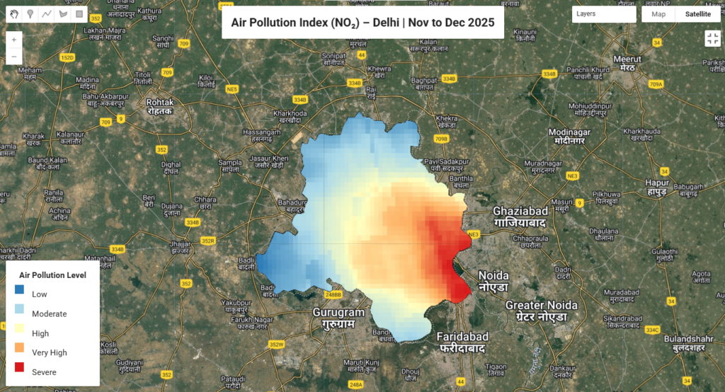
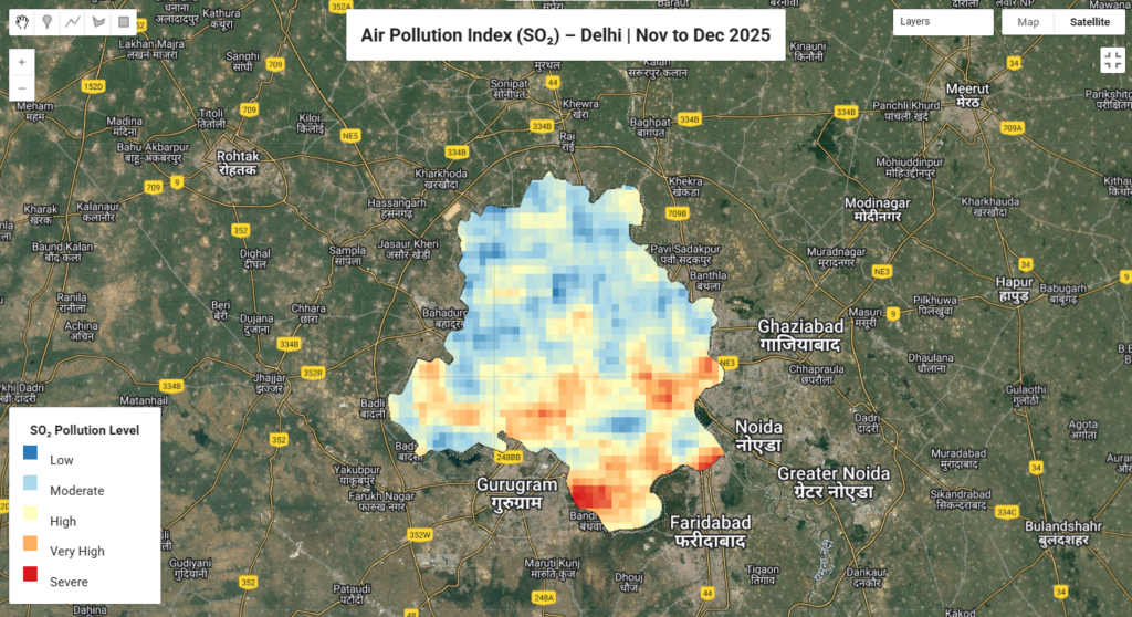
These sensors measure key pollutants such as nitrogen dioxide (NO₂), sulfur dioxide (SO₂), carbon monoxide, and ozone. As satellites repeatedly orbit the Earth, they generate continuous datasets, effectively creating a global, 24/7 satellite-based air quality monitoring system.
Unlike ground-based monitoring stations, which are limited to fixed locations, satellite imagery and remote sensing technologies provide uniform coverage across cities, rural landscapes, oceans, and remote regions where monitoring infrastructure is often absent.
Cross-Border Air Quality Monitoring at a Global Scale
Air pollution is inherently transboundary. Dust storms, wildfire smoke, and industrial emissions routinely cross national borders, affecting neighboring countries and even entire continents. Saharan dust reaching the Americas or wildfire smoke impacting air quality across multiple countries are well-documented examples.
Satellite-based GIS mapping provides a comprehensive view of these pollution movements. By tracking pollution plumes over time, geospatial data and spatial intelligence help identify emission sources, transport pathways, and impacted regions—critical inputs for regional cooperation and international air quality frameworks.
Transforming Satellite Data into Actionable Air Quality Insights
Satellite observations alone are not sufficient. To generate meaningful insights, raw satellite data must be processed and analyzed using GIS software, geospatial analytics, and AI-driven models.
These systems convert satellite measurements into estimates of ground-level pollutant concentrations, enabling air quality mapping, hotspot identification, and seasonal trend analysis. Historical satellite datasets further support policy evaluation by assessing the impact of emission controls, clean energy transitions, and regulatory measures.
In India and other regions, organizations increasingly rely on high-resolution satellite imagery and remote sensing services from experienced geospatial service providers to support air pollution monitoring and environmental reporting.
Global Air Pollution Trends Revealed by Satellite Imagery
Satellite-based environmental monitoring continues to reveal critical global air quality trends. Persistent pollution hotspots are observed over major urban and industrial centers, while climate-driven events such as wildfires increasingly affect air quality across vast regions.
Satellite data has also highlighted the contribution of transportation, industrial activity, and agriculture to air pollution—insights that are often underestimated by ground-only monitoring systems. These findings underscore the importance of continuous satellite-based geospatial monitoring.
Technology Behind Satellite-Based Air Pollution Monitoring
Satellite air quality monitoring relies on spectroscopic sensors, thermal sensors, and LIDAR-based remote sensing systems to detect pollutants and analyze atmospheric layers.
High-performance computing and cloud-based GIS platforms process massive satellite datasets into interactive maps, dashboards, and spatial models—supporting high-resolution air pollution analysis at regional and global scales.
Real-World Applications of Cross-Border Pollution Tracking
Satellite-based air pollution monitoring is already delivering measurable impact. In Europe, geospatial intelligence supports cross-border industrial emission management. In Asia, satellite imagery and GIS analytics enable cooperative pollution tracking across national boundaries. In North America, satellite data has improved wildfire smoke monitoring and public health advisories.
Conclusion
Satellite-based air pollution monitoring has transformed how air quality is tracked, analyzed, and managed across borders. By integrating satellite imagery, remote sensing, GIS mapping, and geospatial intelligence, policymakers now have unprecedented visibility into pollution sources and long-term environmental trends.
As environmental challenges intensify, geospatial technologies will play an increasingly central role in building cleaner and healthier communities. For organizations seeking to leverage satellite data and GIS analytics for environmental monitoring, Satpalda provides expert geospatial services, high-quality satellite imagery, and advanced remote sensing solutions to support informed decision-making.
Dr. Deepak Kumar Raj
Product Specialist


