Axelspace GRUS Satellites | High-Resolution Earth Observation Constellation
Platform, Vision & Value
GRUS is a next-generation remote sensing microsatellite developed by Axelspace, designed to redefine high-frequency Earth observation through a scalable satellite constellation. With a compact mass of approximately 100 kg, GRUS delivers high-resolution satellite imagery at 2.5 m ground resolution, making timely, accurate, and affordable geospatial data accessible to a wider range of users. The constellation was initiated with the first successful launch in 2018, followed by multiple satellites to enable rapid global coverage. By replacing traditional large, high-cost satellites with advanced microsatellite technology, GRUS dramatically reduces imagery acquisition costs while significantly improving revisit frequency. This approach eliminates long waiting times and enables consistent access to fresh satellite data. Through the AxelGlobe platform, organizations can seamlessly access up-to-date imagery for mapping, GIS analysis, environmental monitoring, infrastructure planning, and urban development, supporting faster insights and more confident decision-making.
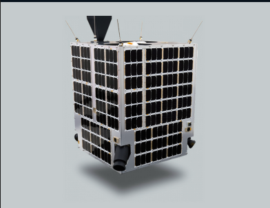
GRUS Satellite – Technical Overview
Client: Axelspace Corporation
Satellite Dimensions: 600 × 600 × 800 mm (excluding protrusions)
Mass: 100 kg
Orbit Type: Sun-Synchronous Orbit (SSO)
Orbital Altitude: 550 km
Launch & Operational Details
GRUS-1A
Launch Date: December 23, 2018 – 08:50 AM (JST)
Launch Vehicle: Soyuz-FG
Current Status: Operational
GRUS-1B, 1C, 1D, 1E
Launch Date: March 22, 2021 – 06:07 AM (JST)
Launch Vehicle: Soyuz-2
Current Status: Operational
Imaging Capabilities & Industry Applications
GRUS is equipped with advanced optical sensors capable of capturing high-resolution panchromatic imagery at 2.5 m resolution, alongside multispectral data in blue, green, red, red-edge, and near-infrared bands. This spectral richness enables detailed land analysis, vegetation monitoring, surface change detection, and environmental assessment. Each satellite provides a wide imaging swath exceeding 50 km, allowing efficient large-area coverage in a single pass. The growing GRUS constellation enables near-daily revisit capability, supporting time-sensitive applications across agriculture, forestry, fisheries, disaster response, urban planning, infrastructure development, and geospatial intelligence. High-temporal-resolution satellite data empowers users to monitor trends, identify early risks, assess seasonal variations, and predict future changes. Continuous satellite deployments further strengthen coverage density and data reliability, positioning GRUS as a powerful Earth observation solution for organizations seeking accurate, scalable, and future-ready geospatial intelligence.