Mapping Red Panda Habitat in Sikkim Using GIS and Climate-Based Suitability Analysis
The red panda (Ailurus fulgens) is a small, arboreal mammal native to the temperate forests of the eastern Himalayas and southwestern China. Recognized for its reddish-brown fur, long bushy tail, and distinctive facial markings, the red panda plays an important ecological role in forest ecosystems by supporting seed dispersal and regulating bamboo growth. Currently classified as Endangered by the IUCN, the species faces increasing threats from habitat loss, landscape fragmentation, and poaching. The primary objective of this study is to identify, map, and analyze potential red panda habitats in the state of Sikkim, India, using spatial analysis and habitat suitability modeling.

The analysis demonstrated strong predictive performance, achieving an overall accuracy of 95%. Annual precipitation emerged as the most influential variable (45.3%), followed by land use and land cover (17.6%) and the maximum temperature of the warmest month (16.0%).
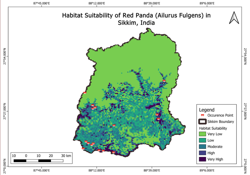
Results indicate that southern and western Sikkim, particularly forested mid-elevation zones between 2,000 and 3,500 meters, exhibit the highest habitat suitability for red pandas. In contrast, fragmented landscapes and areas with significant human disturbance showed moderate to low suitability. These findings underscore the critical influence of climatic conditions and land-use patterns on red panda habitat distribution and conservation planning.
Parameter
Description
Location
Sikkim, India
Geographical Extent
Approximately 7,096 km2, situated in the Eastern Himalayas
Topography
Highly mountainous with elevation ranging from 280 m to 8,586 m
Ecological context
A biodiversity hotspot characterized by temperate broadleaf and conifer forests, suitable for Red Panda habitation
Conclusion
This study highlights how GIS-based habitat suitability analysis can support red panda conservation by identifying high-priority forest zones in Sikkim. The results clearly show that climate variables and land-use patterns strongly influence habitat availability. By mapping suitable regions and recognizing areas under human pressure, geospatial intelligence provides conservation planners and policymakers with actionable insights to protect critical red panda habitats and guide sustainable land management strategies.
Amit Thakur
GIS Engineer