GIS Survey vs Traditional Land Surveying: Understanding the Key Differences

How is land mapped for roads, housing projects, agriculture, or large infrastructure development? For decades, land surveyors relied on manual tools such as measuring tapes, compasses, and basic optical instruments. While these traditional land surveying methods are still widely used, modern technology has introduced GIS surveys, powered by satellite imagery, remote sensing, and geospatial analysis.
Today, decision-makers often ask: does a GIS survey replace traditional land surveying, or do both still play important roles? Understanding the difference between these approaches helps determine which method is best suited for your project.
Key Takeaways
- GIS surveys capture large-scale land data quickly using satellite imagery and geospatial tools
- Traditional land surveying delivers high-precision, on-ground measurements
- The best approach depends on project scale, accuracy requirements, cost, and purpose
- GIS surveys rely on data from geospatial data providers and satellite imagery providers in India
Today, decision-makers often ask: does a GIS survey replace traditional land surveying, or do both still play important roles? Understanding the difference between these approaches helps determine which method is best suited for your project.
Why GIS Mapping Saves Time and Cost
GIS converts raw spatial data into actionable digital maps showing roads, land use, elevation, and risk zones. Tasks that once took months can now be completed in days using automated GIS workflows and satellite datasets. Cities and agencies increasingly rely on GIS mapping for infrastructure planning, utilities, drainage systems, and risk assessment.
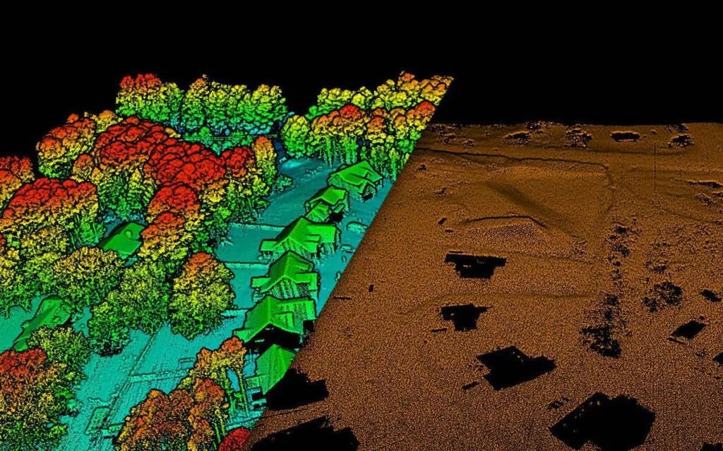
How a GIS Survey Works
A GIS survey collects land information using satellite imagery, remote sensing, GPS, and digital maps. Unlike traditional methods, GIS does not always require physical access to the site, making it ideal for large or difficult-to-reach areas. Using high resolution satellite images in India, GIS systems can analyze land use, vegetation cover, drainage patterns, elevation models, and infrastructure networks.
Data from platforms such as Cartosat, WorldView, and Pleiades imagery providers allows planners to visualize land conditions with strong spatial accuracy. GIS surveys are widely used in urban planning, agriculture, disaster management, environmental monitoring, and regional development. While GIS excels at large-area analysis and pattern detection, it may not capture minute terrain variations as precisely as ground-based surveys.
GIS Survey vs Traditional Surveying: What’s the Difference?
Traditional land surveying involves physical measurements using instruments like total stations, theodolites, DGPS, and measuring tapes. Surveyors must be present on-site, making the process slower but extremely precise. This method is essential for property boundaries, legal land records, construction layout, and engineering design.
In simple terms, GIS surveys provide the big picture, while traditional surveys deliver fine-detail accuracy. GIS is best for mapping cities, forests, agricultural zones, and infrastructure corridors, whereas traditional surveying is critical when exact measurements and legal precision are required. In practice, many projects successfully combine both methods for optimal results.
Role of Satellite Imagery in GIS Surveying:
Satellite imagery is the backbone of modern GIS surveys. It allows surveyors and planners to view land from above, monitor changes over time, and assess large regions efficiently. Many organizations now rely on satellite imagery in India sourced from trusted GIS and remote sensing companies to support planning and monitoring.
With support from remote sensing services in India, GIS surveys can track crop health, urban expansion, surface temperature, infrastructure growth, and climate impacts. Satellite-based GIS mapping has also proven valuable in disaster response by enabling rapid assessment of affected areas.
Remote Sensing vs Traditional Land Surveys:
Remote sensing collects data using satellites and aerial sensors that detect reflected energy from the Earth’s surface. It is ideal for monitoring environmental changes, forests, water bodies, and large landscapes. Traditional surveys, on the other hand, focus on exact ground measurements needed for construction, ownership records, and legal boundaries.
Remote sensing is fast, scalable, and cost-effective for regional analysis, while traditional land surveying remains essential when precision cannot be compromised.
Final Thoughts:
GIS surveys and traditional land surveying both play vital roles in modern land mapping. GIS surveys offer speed, scalability, and powerful analysis, while traditional surveys provide unmatched precision for legal and engineering needs. Choosing the right approach depends on your project’s size, accuracy requirements, and objectives.
Looking for reliable GIS mapping or satellite data solutions? Visit Satpalda.co, your trusted partner for advanced geospatial services supported by leading geospatial data providers and satellite imagery providers in India.