
Hydrothermal Alteration Zone Mapping in Mohammad Bazar, West Bengal
Identifying Clay Mineral Rich Zones Using Landsat 8 OLI Satellite Imagery. Explore the application of multispectral satellite imagery and band ratio techniques to identify hydrothermal alteration signatures, map clay mineral rich areas and understand their spatial distribution across Mohammad Bazar, Birbhum district, West Bengal.
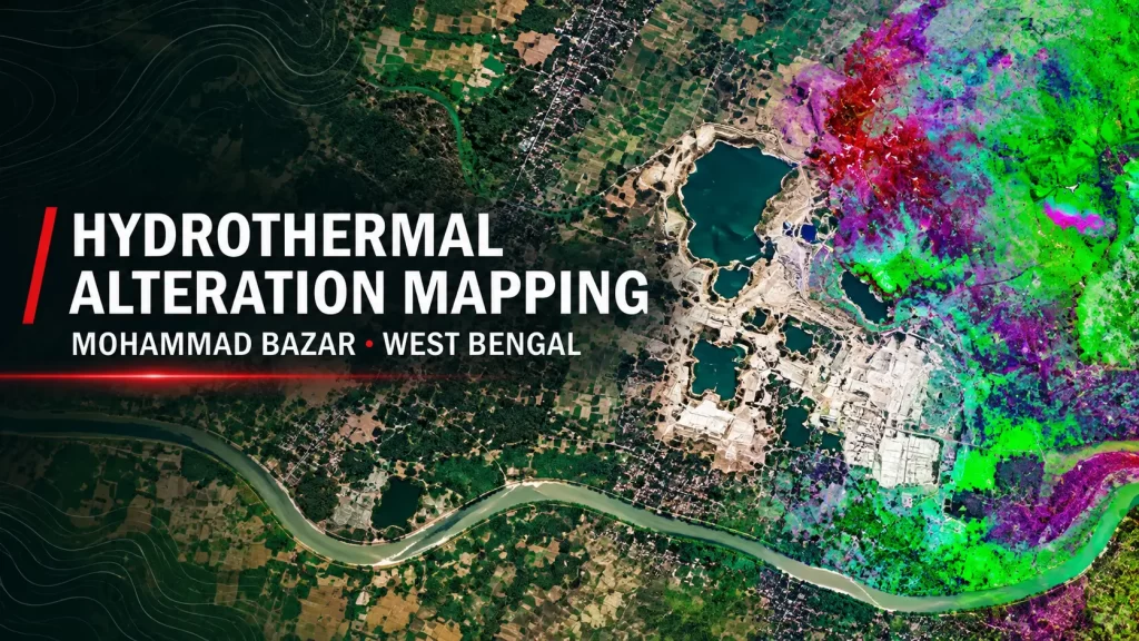
Introduction and Study Area
Mohammad Bazar block, located in Birbhum district of West Bengal, is geologically significant for its extensive clay mineral deposits, particularly kaolinite, fire clay and other hydroxyl bearing minerals associated with alteration processes.
The region’s geological setting and proximity to older metamorphic terrains make it an important area for investigating mineral alteration and clay rich surface materials. These resources have economic relevance for industries such as ceramics, paper, rubber and paint.
This study applies the multi ratio methodology described by Banerjee et al. (2019), originally developed in the context of mineral prospectivity mapping in the Singhbhum Shear Zone, to examine hydrothermal alteration signatures in Mohammad Bazar.
Using Landsat 8 OLI satellite imagery, the analysis combines RGB composites and spectral band ratios to identify and interpret mineralogical variations across the study area. Particular attention is given to an active clay mining site, a riverbed dominated landscape and the wider regional alteration patterns.
Satellite Data and Spectral Analysis
The study uses Landsat 8 Operational Land Imager (OLI) data to investigate the spectral characteristics of clay mineral-rich surfaces and identify possible hydrothermal alteration zones.
Multiple band combinations and spectral ratios were applied to distinguish iron oxide bearing materials, hydroxyl-bearing minerals and ferrous mineral responses. The resulting RGB composites provide different perspectives on the spatial distribution of alteration signatures across the mining site, riverbed and wider study area.
RGB Composites
Hover ↗True-colour satellite imagery used to understand surface characteristics, mining activities, vegetation, settlements and water bodies.
Sabins Ratio
Hover ↗Combines iron oxide, hydroxyl-bearing and ferrous mineral responses for alteration mapping.
Kaufman Ratio
Hover ↗Uses SWIR and NIR band relationships to distinguish clay-rich surfaces and vegetation or moisture-bearing areas.
Hasim and Pour & Hasim
Hover ↗Additional ratio composites used to examine thermal response, vegetation separation and alteration signatures.
Identifying Hydrothermal Alteration at the Active Clay Mining Site
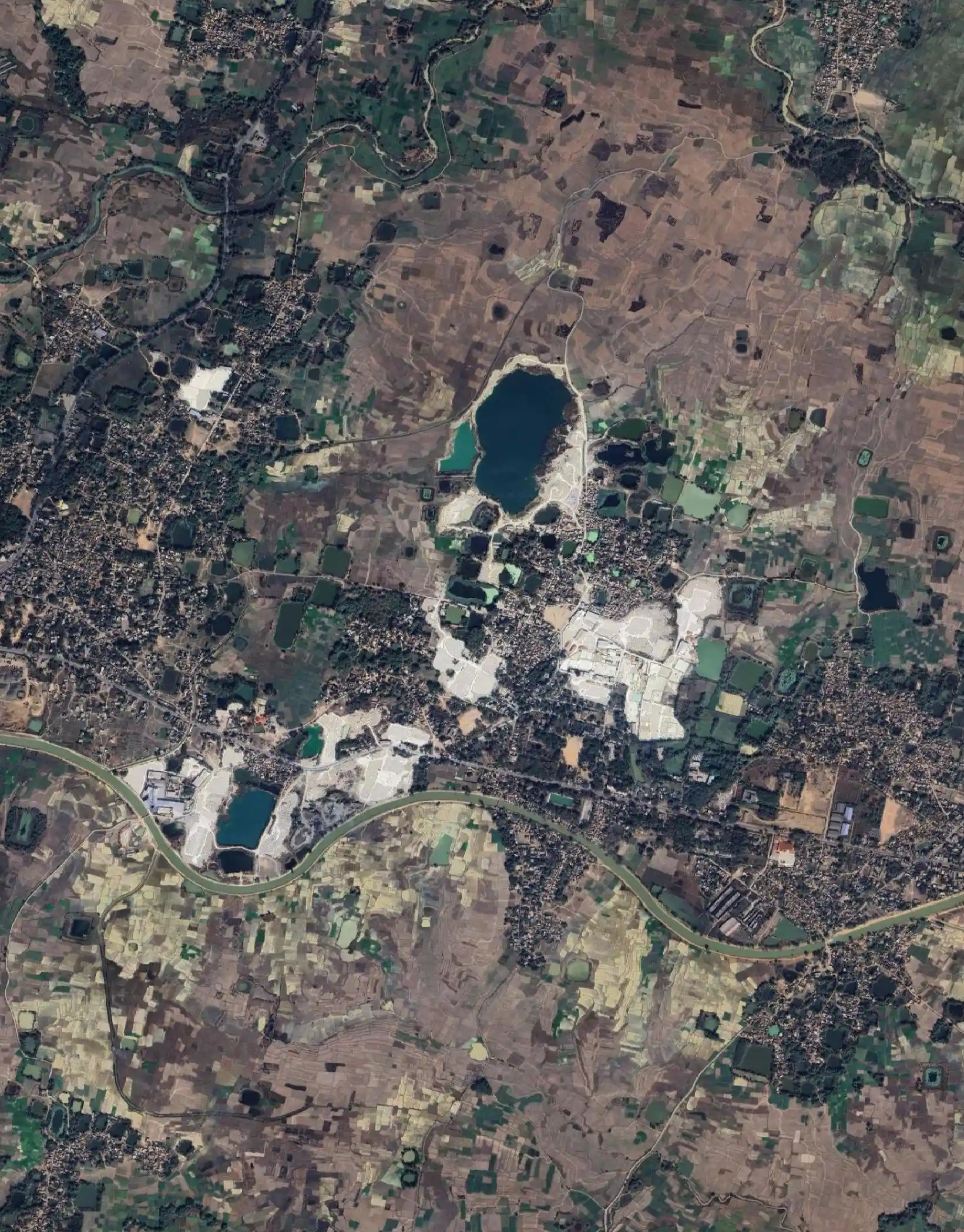
The active clay mining site in Mohammad Bazar displays a highly disturbed landscape characterised by large open cast quarry pits and extensive exposed clay surfaces.
The true colour satellite imagery reveals bright white areas of freshly exposed clay material, surrounded by dark teal water filled excavation pits. Roads, settlements and agricultural patches are visible around the extraction zone, while the overall landscape is dominated by exposed mineral surfaces.
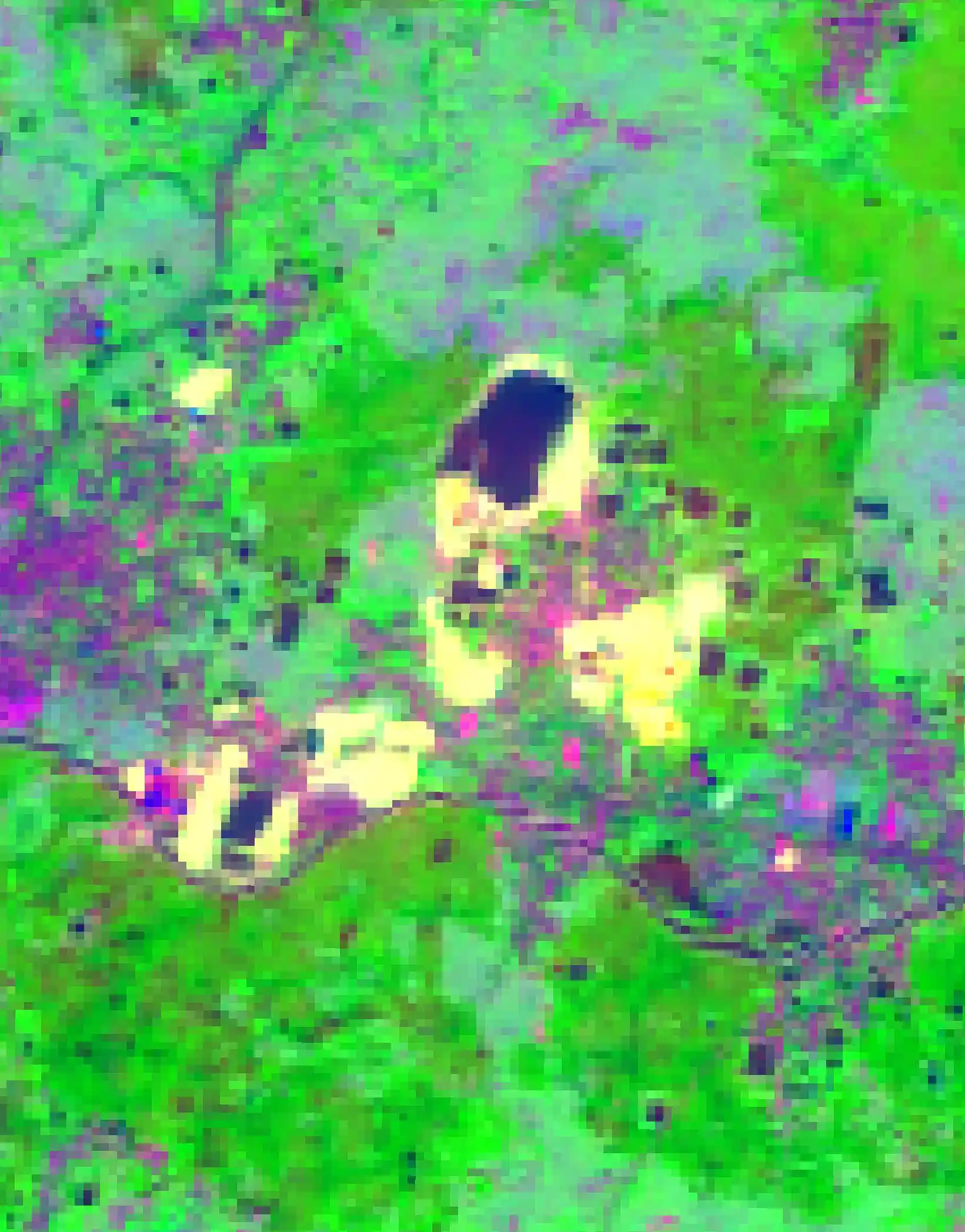
To investigate the mineralogical characteristics of this location, the Sabins band ratio composite was applied to the same area. The resulting imagery highlights strong hydroxyl bearing mineral responses, particularly across the exposed mining surfaces.
Bright green spectral responses are associated with the B6/B7 ratio, which is sensitive to hydroxyl bearing minerals such as kaolinite, illite and montmorillonite. Yellow white patches correspond to exposed clay benches and waste dumps, while dark areas represent water filled quarry pits.
The spatial correspondence between the exposed mining surfaces in the true colour image and the spectral anomalies in the alteration composite demonstrates the usefulness of multispectral band ratio analysis for identifying clay rich surface materials.
Spectral Alteration Signatures Across the Riverbed Landscape
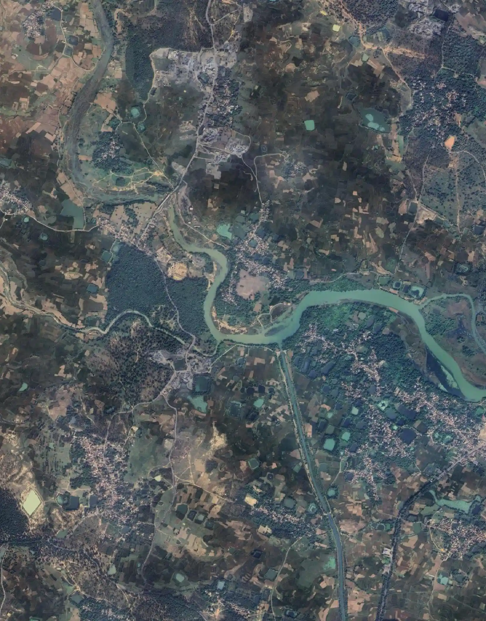
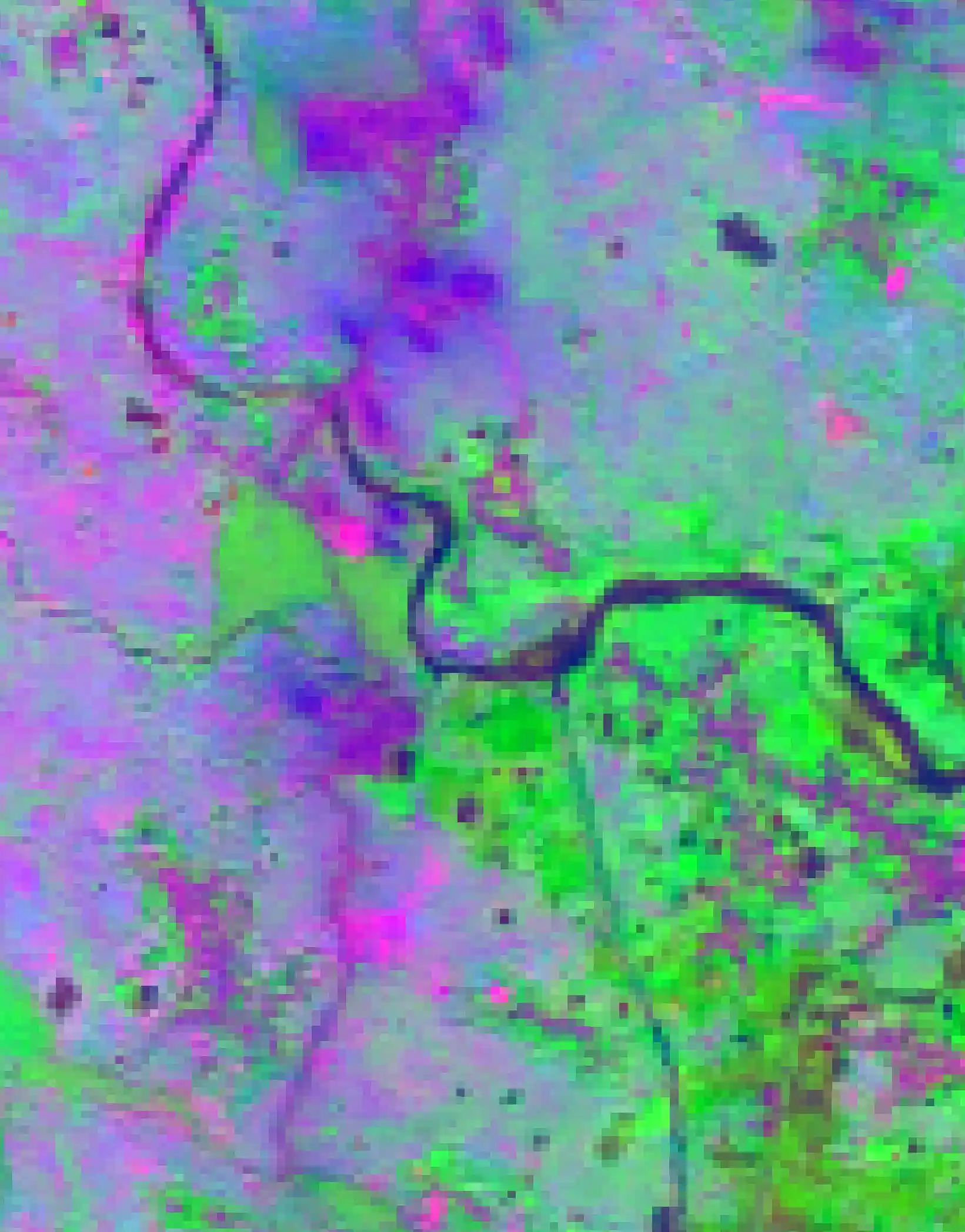
The riverbed site presents a different landscape from the active mining zone. The true colour satellite imagery shows a meandering river surrounded by riparian vegetation, agricultural fields, scattered rural settlements and exposed floodplain sediments.
The area exhibits considerable surface variability, with dense vegetation, fallow agricultural land and sediment deposits contributing to a heterogeneous landscape.
The Sabins band ratio composite reveals a mixture of purple magenta, blue and green spectral responses. Compared with the mining site, the hydroxyl bearing mineral response is less dominant and appears in fragmented patches, potentially corresponding to weathered sediments and exposed hydroxyl bearing material along the riverbanks.
The magenta purple signatures indicate a combination of iron oxide and ferrous mineral responses within the floodplain sediments. The river itself displays a dark spectral response, while adjacent exposed sediment bars and channel banks exhibit localised alteration signatures.
These patterns illustrate how clay bearing materials may be redistributed through fluvial processes, in addition to forming through in situ weathering.
Mapping Hydrothermal Alteration Across Mohammad Bazar
Beyond the two detailed locations, the study applies four different band-ratio combinations across the wider Mohammad Bazar region to investigate the distribution of hydrothermal alteration signatures.
Each composite uses a different combination of spectral responses to distinguish altered surfaces, hydroxyl bearing minerals, iron oxide signatures and vegetation or moisture related features.
The comparison of these outputs helps identify recurring alteration patterns and understand their distribution across the northern, central and southern portions of the study area.
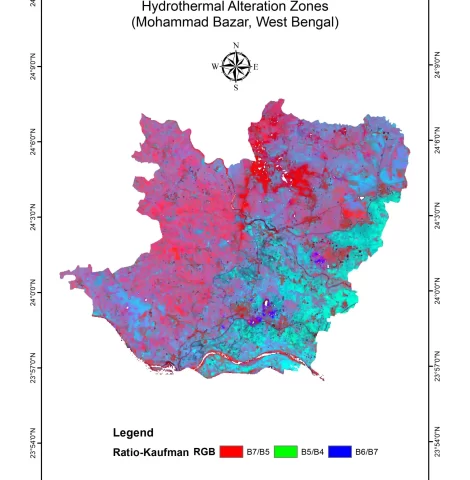
The Kaufman composite uses B7/B5, B5/B4 and B6/B7 in the red, green and blue channels, respectively.
The output shows a strong red dominant response across the central and northern portions of the study area. This response highlights clay mineral rich surfaces where SWIR-2 reflectance is relatively strong compared with NIR reflectance.
Cyan and teal zones across the eastern and southeastern portions correspond to vegetation covered or moisture bearing surfaces. Concentrated blue channel responses indicate discrete hydroxyl bearing mineral signatures, particularly in the northern part of the region.
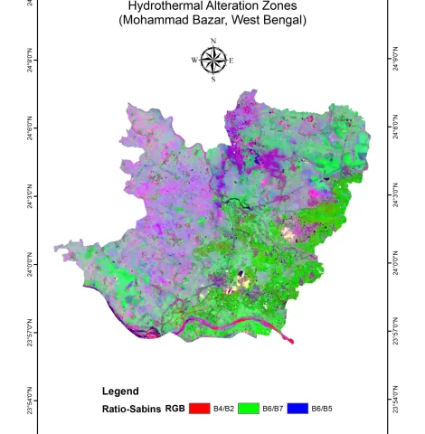
The Sabins composite combines B4/B2, B6/B7 and B6/B5 as red, green and blue channels.
The output shows persistent violet magenta responses across the northern, central western and northeastern portions of Mohammad Bazar. These patterns represent the combined spectral responses of iron oxide bearing materials, hydroxyl bearing minerals and ferrous mineral signatures.
Strong green patches in the northeastern quadrant indicate hydroxyl mineral dominated surfaces. The spatial concentration of these responses suggests that the northern part of the study area contains significant alteration signatures.
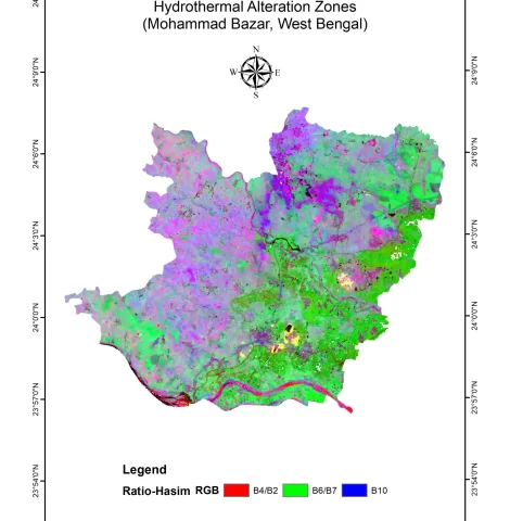
The Hasim composite uses B4/B2, B6/B7 and B10 as the red, green and blue channels, introducing the thermal infrared band into the analysis.
The resulting map shows violet magenta alteration signatures in locations similar to those identified in the Sabins composite. This consistency strengthens the interpretation of a persistent northern alteration corridor.
The southeastern quadrant shows additional differentiation, where the thermal response helps distinguish exposed quarry waste and soil from vegetated surfaces.
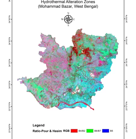
The Pour & Hasim composite combines B4/B2, B6/B7 and B5 as red, green and blue channels.
The output highlights a strong red concentration in the north central zone, associated with iron oxide rich altered surfaces. Widespread cyan tones across the southern agricultural plains indicate vegetation or moisture-related responses.
The active mining zone also displays distinctive mixed spectral signatures, corresponding to exposed clay materials and freshly excavated surfaces.
Key Findings and Geological Significance
The combined interpretation of all four band ratio composites reveals three major spatial patterns across the Mohammad Bazar study area.
The consistency of hydroxyl-bearing and iron oxide spectral responses across multiple composite techniques provides a broader understanding of the distribution of alteration signatures and their relationship with the region’s clay rich geology.
Northern Alteration Corridor
Hover to explore ↗The northern and north-central portions of the study area consistently display hydroxyl-bearing and iron oxide responses across the four ratio composites. These patterns indicate zones of comparatively intense argillic alteration and potentially concentrated clay mineral resources.
Spectral Response of the Mining Zone
Hover to explore ↗The central mining area exhibits distinctive spectral anomalies across the different composite outputs. The correspondence between exposed kaolinite surfaces and SWIR-based spectral responses supports the use of band-ratio techniques for identifying clay-rich mining surfaces.
Southern Agricultural and Riverine Zone
Hover to explore ↗The southern portion displays transitional alteration signatures associated with agricultural surfaces, riverine sediments and potentially redistributed lateritic and clay-bearing materials.
Conclusion
The study demonstrates the application of freely available Landsat 8 OLI imagery and multispectral band ratio techniques for identifying and interpreting hydrothermal alteration signatures across Mohammad Bazar, West Bengal.
The consistent patterns observed across the Sabins, Kaufman, Hasim and Pour & Hasim composites highlight the northern and north central portions of the study area as important alteration corridors. The active mining site demonstrates the ability of SWIR-based ratios to capture exposed clay rich surfaces, while the riverbed analysis reveals the influence of fluvial processes on the distribution of mineral bearing sediments.
By adapting the multi ratio framework of Banerjee et al. (2019), the study demonstrates a practical, low cost approach to regional mineral alteration assessment. The results can support preliminary identification of clay rich zones, quarry expansion planning and monitoring of the environmental footprint of ongoing extraction activities.
The approach offers a useful remote sensing framework for geological investigations and mineral resource assessment, while detailed field verification remains important for confirming mineral composition and economic potential.
Himansh Ameta
GIS Engineer