From Hyperspectral Satellite Data to Actionable Geospatial Intelligence
The true value of Earth observation lies not just in collecting satellite data, but in transforming that data into insights that decision-makers, operators, and analysts can confidently act upon. Raw imagery alone rarely answers operational questions. What organizations need is context, interpretation, and decision-ready intelligence.
This is precisely where Satpalda and Wyvern come together as complementary partners. Wyvern delivers advanced space-based hyperspectral satellite data, while Satpalda provides end-to-end geospatial intelligence, analytics, and implementation frameworks. Together, they bridge the gap between complex hyperspectral datasets and real-world operational decisions across agriculture, environment, energy, mining, and governance.
Wyvern: High-Resolution Hyperspectral Vision from Space
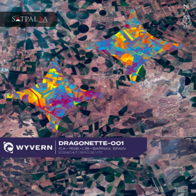
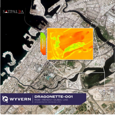
Wyvern operates a next-generation hyperspectral satellite constellation designed to reveal information that remains invisible to conventional optical imagery. Unlike traditional multispectral satellites, hyperspectral sensors capture data across hundreds of narrow spectral bands, enabling highly detailed material and surface analysis.
This spectral richness allows accurate identification and differentiation of:
- Vegetation health and stress indicators
- Soil composition and moisture variability
- Surface materials and land-cover characteristics
- Subtle environmental and ecological changes over time
Wyvern’s hyperspectral capabilities are delivered through flexible and scalable access models, including:
Constellation Tasking for on-demand hyperspectral data acquisition, enabling users to capture imagery when and where it matters most.
Archive Library Access for rapid retrieval of historical hyperspectral datasets, supporting time-series analysis, trend detection, and long-term environmental monitoring.
Assured Capacity Services that guarantee priority imaging for critical projects, regulatory programs, or time-sensitive operations.
Together, these offerings provide reliable, timely, and globally scalable hyperspectral satellite data for applications spanning agriculture, forestry, environment, energy, mining, and public-sector governance.
Satpalda: Turning Satellite Data into Decisions
While hyperspectral data offers immense analytical potential, its true power is realized only when it is processed, interpreted, and delivered in operationally meaningful formats. This is where Satpalda’s geospatial intelligence expertise plays a critical role.
Satpalda specializes in:
- Earth observation analytics
- GIS and spatial modeling
- Environmental and land-use monitoring
- Decision-support systems and geospatial dashboards
Satpalda’s role in the partnership is to translate Wyvern’s hyperspectral satellite data into actionable intelligence aligned with operational workflows, regulatory requirements, and commercial objectives. Rather than delivering raw data, Satpalda ensures insights are accessible to planners, regulators, and operators—not just remote sensing specialists.
How Satpalda and Wyvern Work Together
1. Strategic Data Acquisition and Planning
Effective geospatial intelligence begins with the right data strategy. Wyvern supplies high-quality hyperspectral imagery through tasking, archive access, or assured capacity. Satpalda complements this by supporting:
- Precise Area of Interest (AOI) definition
- Temporal planning for continuous monitoring programs
- Selection of optimal acquisition strategies based on use case, geography, and seasonality
This coordinated approach ensures data is collected with a clear operational purpose, reducing unnecessary acquisition costs and improving analytical relevance.
2. Advanced Hyperspectral Analytics
Once hyperspectral data is acquired, Satpalda applies advanced analytics to extract meaningful insights. Using Wyvern’s data, Satpalda performs:
- Spectral analysis and material discrimination
- Vegetation health, stress, and biochemical assessment
- Soil variability and moisture analysis
- Land-cover and land-use classification
These workflows enable accurate separation of signal from noise, reduced spectral mixing, and improved environmental stratification. For decision-makers, this translates into higher confidence insights. For data scientists and analysts, it results in cleaner datasets and stronger analytical models.
3. Use Case–Driven Solutions Across Industries
The combined Satpalda–Wyvern offering supports a wide range of operational use cases by aligning hyperspectral analytics with domain-specific requirements.
Agriculture and Soil Intelligence
In agriculture, hyperspectral satellite data enables early detection of crop stress and disease—often before visual symptoms appear. Key applications include:
- Crop classification and acreage estimation
- Vegetation health monitoring and stress detection
- Soil variability mapping and optimized soil sampling
- Monitoring regenerative agriculture and sustainability programs
These insights help agribusinesses and policymakers improve productivity while reducing environmental impact.
Forestry and Environmental Monitoring
For forestry and environmental agencies, hyperspectral analytics support:
- Forest inventory management and biomass assessment
- Detection and monitoring of invasive species
- Long-term land-cover and ecosystem change analysis
- Biodiversity and habitat monitoring
Such capabilities are critical for conservation planning, regulatory compliance, and climate resilience strategies.
Energy, Mining, and Land Reclamation
In energy and mining sectors, hyperspectral data plays a vital role in environmental compliance and land rehabilitation:
- Oil and gas wellsite reclamation monitoring
- Open-pit mine reclamation assessment
- Verification of vegetation regrowth and soil stability
- ESG and regulatory reporting support
Satpalda ensures these insights are delivered in formats that support audits, compliance verification, and operational decision-making.
4. Decision Support, Reporting, and Compliance
Satpalda converts advanced hyperspectral analytics into decision-ready outputs, including:
- Interactive GIS-based dashboards
- Technical reports and spatial documentation
- Monitoring frameworks aligned with regulatory and ESG requirements
This enables organizations to move seamlessly from observation to validation, and from validation to action—closing the gap between satellite data and real-world outcomes.
Who Benefits from the Satpalda–Wyvern Partnership
The combined offering supports a diverse range of stakeholders, including:
- Government agencies and regulators
- Agriculture and agribusiness organizations
- Forestry and environmental authorities
- Mining and energy operators
- Environmental consultancies
- Data scientists and geospatial analysts
For decision-makers, the partnership reduces field dependency, uncertainty, and operational risk.
For analysts, it delivers higher-quality hyperspectral data and stronger analytical workflows.
For operators, it enables repeatable, scalable, and cost-effective monitoring programs.
A Complete End-to-End Geospatial Intelligence Solution
Wyvern delivers what is happening on the ground through advanced hyperspectral satellite imaging. Satpalda delivers what it means and what should be done next through geospatial analytics and decision-support systems.
Together, they provide:
- Space-based hyperspectral data acquisition
- Advanced hyperspectral analytics and interpretation
- Domain-specific intelligence tailored to real-world use cases
- Actionable insights for operational, regulatory, and commercial outcomes
This partnership enables organizations to manage land, resources, and the environment with greater accuracy, lower risk, and higher confidence, transforming hyperspectral data into operational intelligence at scale.
Chaitali Bhattacharya
Senior GIS Engineer