SAR vs Optical satellite Imagery: Strengths, Limitations, and Best Use Cases
Introduction: Two Powerful Ways to See the Earth
Satellite imagery is at the heart of modern Earth Observation, but not all imagery is created equal. Among the most widely used technologies today are Optical satellite imagery and Synthetic Aperture Radar (SAR) imagery. Each offers unique capabilities, advantages, and limitations—and choosing the right one can determine the success of a project.
In 2026, organizations no longer ask whether to use satellite imagery, but which type best suits their operational and strategic needs. From agriculture and urban planning to disaster response and national security, understanding the difference between SAR and optical imagery is essential.
In this vlog, we break down SAR vs Optical imagery, explaining how they work, where each excels, where they fall short, and the best real-world use cases for each.
What Is Optical Satellite Imagery?
How Optical Imagery Works
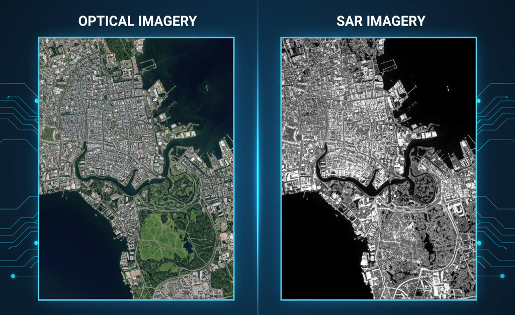
Optical satellite imagery captures reflected sunlight from the Earth’s surface, similar to how a digital camera works. These sensors operate in the visible, near-infrared, and sometimes shortwave infrared spectrum.
Modern optical satellites can capture imagery at resolutions as fine as 30 cm, revealing buildings, roads, vehicles, vegetation patterns, and land-use changes in stunning detail.
Companies such as Vantor are leaders in high-resolution optical imagery used globally for commercial, civil, and defense applications.
Strengths of Optical Imagery
Optical imagery remains the most intuitive and widely used form of satellite data because it closely resembles what the human eye sees.
Key strengths include:
- High spatial resolution and visual clarity
- Easy interpretation for non-technical users
- Ideal for mapping, visualization, and communication
- Strong historical archives for long-term analysis
Limitations of Optical Imagery
Despite its advantages, optical imagery has important constraints:
- Dependent on sunlight (no night imaging)
- Severely affected by clouds, haze, smoke, and dust
- Limited usability in tropical, monsoon, or polar regions
In regions with frequent cloud cover, optical imagery alone is often insufficient for continuous monitoring.
What Is SAR (Synthetic Aperture Radar) Imagery?
How SAR Imagery Works
SAR imagery uses active radar signals instead of sunlight. The satellite sends microwave pulses toward Earth and measures the reflected signal to create images.
Because radar waves penetrate clouds and operate independently of daylight, SAR provides all-weather, day-and-night imaging, making it one of the most reliable Earth Observation technologies.
Space agencies like the European Space Agency have played a critical role in advancing SAR through open and commercial missions.
Strengths of SAR Imagery
SAR imagery offers unique capabilities unavailable to optical sensors.
Key strengths include:
- Works in all weather conditions
- Operates day and night
- Sensitive to surface roughness, moisture, and movement
- Ideal for change detection and deformation analysis
SAR can detect millimeter-level ground movement, making it indispensable for infrastructure monitoring and disaster risk assessment.
Limitations of SAR Imagery
While powerful, SAR imagery comes with its own challenges:
- Less intuitive and harder to interpret visually
- Requires specialized processing and expertise
- Speckle noise can affect raw image clarity
For this reason, SAR is often combined with optical imagery for maximum insight.
SAR vs Optical Imagery: Side-by-Side Comparison
Visual Interpretation
- Optical: Photo-like, easy to understand
- SAR: Abstract, requires expert interpretation
Weather Dependency
- Optical: Highly affected by clouds and lighting
- SAR: Completely weather-independent
Temporal Reliability
- Optical: Limited in cloudy or rainy regions
- SAR: Consistent, reliable monitoring
Analytical Capabilities
- Optical: Excellent for classification and visualization
- SAR: Superior for deformation, moisture, and structural analysis
Best Use Cases for Optical Imagery
Urban Planning and Mapping
Optical imagery is ideal for mapping roads, buildings, land use, and infrastructure growth. City planners rely on its clarity for zoning, development planning, and visualization.
Agriculture and Vegetation Analysis
Multispectral optical imagery supports crop classification, vegetation indices (NDVI), and seasonal growth monitoring—especially in clear-sky regions.
Environmental Monitoring
Optical data is widely used for deforestation tracking, land-cover mapping, and habitat monitoring due to its visual richness.
Best Use Cases for SAR Imagery
Disaster Monitoring and Response
SAR is critical during floods, cyclones, earthquakes, and landslides. It can map flood extent through clouds and assess damage immediately after events.
Infrastructure and Ground Deformation
SAR detects subsidence, uplift, and structural movement in roads, bridges, railways, pipelines, and dams—supporting predictive maintenance and risk mitigation.
Maritime and Security Applications
SAR is highly effective for ship detection, oil spill monitoring, and maritime surveillance, even at night or in poor weather conditions.
The Power of Combining SAR and Optical Imagery
In 2026, the most advanced Earth Observation solutions do not choose between SAR and optical—they use both.
By combining:
- Optical imagery for visual context
- SAR imagery for reliability and motion detection
Organizations gain a more complete, accurate, and resilient understanding of Earth dynamics.
Companies operating high-revisit satellite constellations, such as Planet Labs, further enhance this approach by enabling frequent monitoring and rapid change detection.
AI and the Future of SAR and Optical Analytics
Artificial intelligence has significantly reduced the complexity of working with SAR data. AI models now:
- Automatically interpret SAR signatures
- Fuse SAR and optical data
- Detect changes and anomalies at scale
Institutions like NASA continue to advance AI-powered multisensor Earth Observation systems that convert raw data into decision intelligence.
Choosing the Right Imagery for Your Project
The choice between SAR and optical imagery depends on your objective:
- Need clear visuals? Choose optical imagery
- Cloudy region or night monitoring? Choose SAR
- Infrastructure stability or flood mapping? SAR is ideal
- Land-use mapping or communication outputs? Optical excels
For mission-critical applications, a hybrid SAR + optical strategy delivers the best results.
Conclusion: SAR and Optical Are Complementary, Not Competing
SAR and optical imagery are not rivals—they are complementary tools in the Earth Observation toolbox. Understanding their strengths and limitations allows organizations to make smarter decisions, reduce risk, and maximize the value of satellite data.
In a world facing climate change, rapid urbanization, and increasing disaster risk, using the right imagery at the right time is no longer optional—it’s essential.


