Vantor Satellites
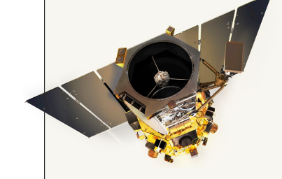
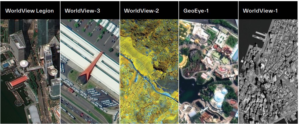
GeoEye-1 Satellite: Ultra-High-Resolution Earth Observation Imagery
Accuracy, Revisit & Operational Benefits
GeoEye-1 delivers industry-leading geolocation accuracy, enabling users to precisely locate surface features with positional accuracy better than 5 meters, even in remote and data-scarce regions. This capability supports highly reliable mapping, infrastructure planning, and mission-critical operations. The satellite’s high imaging capacity allows it to efficiently collect, store, and downlink vast volumes of frequently updated global imagery, ensuring consistent coverage across extensive geographic areas. Additionally, GeoEye-1 supports stereoscopic image acquisition in a single pass, providing high-quality elevation data and three-dimensional terrain insights with superior image continuity. These capabilities make GeoEye-1 a powerful tool for applications such as disaster management, defense intelligence, environmental monitoring, transportation planning, and resource management. By combining ultra-high resolution, rapid revisit, and exceptional positional accuracy, GeoEye-1 enables organizations to extract deeper insights, improve operational efficiency, and reduce risks through precise and timely geospatial intelligence.
Key Features
Ultra-high resolution imagery (0.46 m panchromatic, 1.84 m multispectral)
Industry-leading geolocation accuracy (<5 m CE90)
High daily imaging capacity (up to 500,000 sq km)
Rapid revisit cycle (≤ 3 days)
Single-pass stereoscopic imaging capability
High-volume data collection and downlink
Key Benefits for Users
Enables highly detailed mapping, monitoring, and analysis
Supports precise feature extraction and change detection
Delivers frequent, high-quality global imagery updates
Provides accurate 3D terrain and elevation models
Enhances decision-making across planning, operations, and risk management
WorldView Legion Satellite Constellation: 30 cm Ultra-High-Resolution Earth Observation

Imaging Capabilities & Data Products
WorldView Legion delivers ultra-high-resolution panchromatic imagery at 30 cm class resolution, complemented by 8-band visible and near-infrared (VNIR) multispectral data, enabling advanced surface analysis, feature extraction, and environmental monitoring. The constellation supports industry-leading geolocation accuracy through advanced Direct Access Frameworks (DAFs), ensuring precise positional intelligence even in complex operational environments. WorldView Legion offers three structured product levels: Level 1B Basic Products provide radiometrically calibrated mono and stereo imagery for custom georeferencing and orthorectification workflows; Level 2A/2B Standard Products deliver map-projected imagery with uniform pixel spacing for seamless analysis in GIS and image-processing platforms; and Level 3 Ortho Products provide highly accurate, ready-to-use georeferenced imagery for mapping, visualization, and location-based intelligence. Additional capabilities such as secure direct-access tasking and simultaneous image acquisition, processing, and downlink ensure rapid data delivery for mission-critical applications.
Key Features
Ultra-high-resolution imagery (30 cm class)
8-band VNIR multispectral imaging
Industry-leading geolocation accuracy (DAFs)
Direct Access tasking with customer-unique encryption
Simultaneous receive, image acquisition, and downlink operations
Multi-orbit constellation for rapid revisit
Key Benefits for Users
Enables real-time situational awareness for critical missions
Delivers faster revisit and higher data availability
Supports high-precision mapping and analytics
Enhances operational intelligence and decision confidence
Provides secure, low-latency tasking and data delivery
WorldView Legion Product Levels
Level 1B – Basic Products
Radiometrically calibrated mono and stereo imagery for user-driven georeferencing and orthorectification.
Level 2A / 2B – Standard Products
Map-projected imagery with uniform pixel spacing, optimized for GIS workflows and analytical processing.
Level 3 – Ortho Products
High-accuracy, ready-to-use ortho-rectified imagery for mapping, visualization, and positional intelligence.
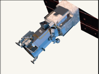
WorldView-3 Satellite: Super-Spectral, Ultra-High-Resolution Earth Observation
Spectral Power & Advanced Applications
WorldView-3 delivers the highest spectral diversity commercially available, featuring 16 multispectral bands across visible, near-infrared, and short-wave infrared wavelengths, along with 12 CAVIS bands for atmospheric correction. Its eight SWIR bands penetrate haze, smoke, fog, dust, and smog, enabling reliable imaging even in challenging environmental conditions. This exceptional spectral richness supports advanced applications including land classification, mineral mapping, soil and vegetation analysis, geological exploration, oil and gas assessment, coastal and bathymetric studies, and environmental monitoring. WorldView-3 also enables precision geolocation without the need for ground control points, ensuring highly accurate positional intelligence. Bi-directional scanning combined with rapid tasking using Control Moment Gyros allows image targeting at speeds up to twice that of conventional satellites. Secure direct-access tasking and real-time data transmission ensure fast delivery of actionable insights for time-critical missions.
Key Features
Ultra-high-resolution panchromatic imagery (31 cm)
Multispectral resolution: 1.24 m (VNIR)
Short-wave infrared resolution: 3.7 m (SWIR)
CAVIS atmospheric correction bands: 30 m
Daily revisit capability
Global imaging capacity: 680,000 sq km per day
Bi-directional scanning for rapid targeting
Secure direct-access tasking and data downlink
Key Benefits for Users
High-precision mapping and urban planning
Advanced land classification and feature extraction
Disaster preparedness and rapid response
Geological, mining, and oil & gas exploration
Soil and vegetation health analysis
Environmental and climate monitoring
Coastal and bathymetric mapping
Spectral Band Capabilities
Panchromatic Band – Ultra-detailed grayscale imaging
8 VNIR Bands:
Blue, Green, Red, Near-IR1, Coastal, Yellow, Red Edge, Near-IR2
8 SWIR Bands:
Enhanced penetration through haze, dust, smoke, fog, and smog
12 CAVIS Bands:
Cloud mapping, aerosol correction, snow and ice detection, atmospheric compensation
Vantor Satellite Constellation: The World’s Most Advanced High-Resolution Imaging Network
Constellation Scale, Accuracy & Global Reach
The Vantor satellite constellation represents the world’s most advanced network of high-resolution Earth observation satellites, delivering unmatched accuracy, agility, and global imaging capacity. Designed to capture the finest level of surface detail, the constellation collects more than one billion square kilometers of high-resolution optical imagery annually, building and continuously refreshing the most comprehensive global imagery library available. This unparalleled collection capability enables organizations worldwide to access up-to-date satellite imagery with exceptional spatial, spectral, and temporal resolution. Vantor’s advanced tasking and delivery systems allow users to request imagery exactly how and when they need it—via web platforms, mobile applications, offline delivery, or direct integration into enterprise GIS environments. With intraday revisits, industry-leading geolocation accuracy, wide swath coverage, and rapid retargeting agility, the Vantor constellation empowers organizations to achieve superior situational awareness, precise mapping, and reliable geospatial intelligence across mission-critical applications.
Key Capabilities
Ultra-high-resolution imaging with crisp surface detail
Highest spectral diversity commercially available
Industry-leading collection capacity
Intraday revisit capability
Exceptional geolocation accuracy
Large-area high-resolution swath width
Rapid retargeting and high agility
Best-in-class in-track stereo collection
WorldView Legion – Constellation Highlights
Six next-generation commercial imaging satellites
Up to 15 revisits per day over the same location
7+ million sq km daily imaging capacity
3.5+ million sq km of 30 cm imagery per day
Comprehensive coverage of high-demand regions
Seamless integration with Vantor’s global access programs