SATPALDA’s 3D landscape dataset is a next-generation, global 3D terrain dataset that provides seamless data with sub-meter post spacing, enabling precise topographic analysis. 3D landscape dataset is available as a Digital Surface Model (DSM), Digital Terrain Model (DTM), and 3D building model, providing comprehensive, worldwide coverage for various industries, including engineering, construction, urban planning, and natural resource management.
The high-resolution data and precise topographic analysis provided by our 3D landscape dataset will enable customers to make more informed decisions, improve project planning and design, and increase operational efficiency.
Our 3D building model provides detailed information about the shape, size, and location of buildings, which can be used for urban planning, emergency management, and other applications. The DSM and DTM data can be used for topographic analysis, such as calculating slope, aspect, and hillshade, as well as for generating 3D visualizations and fly-through animations.
Our 3D landscape dataset is fully integrated with our GIS platform, allowing for easy data access, analysis, and visualization. Customers can also use the data in combination with other satellite and aerial imagery, as well as other GIS layers, to gain a more comprehensive understanding of the landscape.
To learn more about our sub-products please follow the links below:
If you have any questions or would like to learn more about our 3D landscape dataset, please contact us. We would be happy to assist you.
Digital Surface Model (DSM) represents the elevations of the reflective surfaces of trees, buildings, and other features elevated above the “Bare Earth”. It represents the earth’s surface and includes all objects on it.
We use algorithm-based high-end software that is patented to end-to-end photogrammetry solutions for the generation of high-quality geospatial data from satellite and aerial imagery, including UAVs. It builds on unique computer vision algorithms that significantly differ from traditional photogrammetry techniques. Powered by GPU technology and multi-core CPUs, it ensures matchless processing power to support the rapid production of large datasets.
Key Features of the product
Automatic execution of the data with a defined workflow
GCP File Creation: a semi-automatic tool for creating and editing GCPs
Change Detection: identification of 3D changes
Stitching of DSM patches
DSM Inspection: generation of statistics about DSM quality
Point Cloud Colorization: colorization of a point cloud using a mosaic
Simple and user-friendly interface
An unlimited number of images can be processed
Survey-grade accuracy with detailed reports
Fast processing on GPUs and multi-core CPUs
Volume Calculation
Applications of a DSM
These models are used in planning, analysis, visualization, and modeling.
Urban planning, architectural planning, tourism, virtual tours, etc.
For improving the transportation system
Telecommunication
Flood risk analysis and many others.
Runway Approach Zone Encroachment: DSMs in aviation can detect runway obstructions in the approach zone.
Vegetation Monitoring: DSMs can identify where and how much vegetation is intruding on a transmission line.
View Obstruction: DSM is being used by urban planners to evaluate how a proposed building will affect the viewsheds of businesses and residents.
Digital Terrain Model
Digital Terrain Model (DTM) is a bare earth model that is generated using stereo pair of imageries. Such models become an integral part of topographic surveys. These models are also used to generate contour maps. Such models are the best depiction of slopes and aspects.
Digital Terrain Models (DTM) sometimes called Digital Elevation Models (DEM) is a topographic models of the bare Earth that can be manipulated by computer programs. The data files contain the elevation data of the terrain in a digital format that relates to a rectangular grid. Vegetation, buildings, and other cultural features are removed digitally – leaving just the underlying terrain.
How the product is unique?
Next-generation global 3D terrain datasets
Seamless data up to sub-meter post spacing
Precise topographic analysis
Comprehensive worldwide offering
Hydro-enforced – water bodies and coastlines are flattened for accurate measurement
Vintage: most recent or new collected imagery
File format: GeoTIFF or other formats on request
Post Spacing: 50cm to 10m
Inputs Required
Stereo remote sensing imagery
Ground Control Points (GCPs).
Contours
Triangulate Irregular Network (TIN).
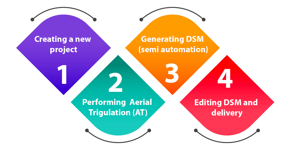
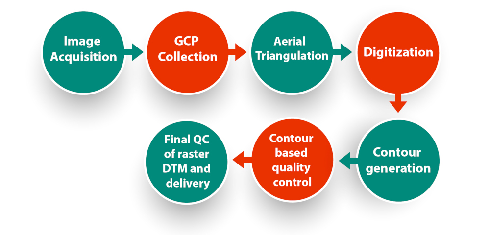
Workflow
Accuracy
Absolute: 50cm to 5m (LE90)
Valid on all-terrain type
Quality of the DTM
DTM is a measurement of how precise the elevation at each pixel is (absolute accuracy) and how precisely the morphology is presented (relative accuracy). So many factors have an impact on the quality of DTM:
Terrain roughness
Extracting terrain parameters
Sampling density (elevation data collection method)
Grid resolution or pixel size
Interpolation algorithm
Vertical resolution
Terrain analysis algorithm
Rendering of 3D visualizations
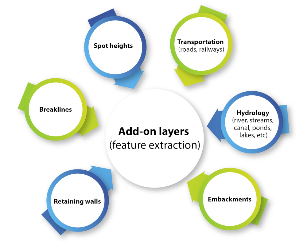
Add-on layers (feature extraction)
Application
DTMs are used especially in civil engineering, geodesy & surveying, geophysics, geography, and remote sensing.
Hydrology modeling
Flood analysis
Irrigation
Feasibility study in infrastructure projects
An essential part of a topographic survey
Volume estimation in mining
Input for orthorectification and many other
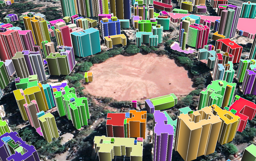
3D Buildings
New developments in urban planning, urban landscape, real estate management, and so on, call for new demands for the 3D Object Model. The building models are the most important in the 3D object model. With the development of 3D data acquisition, the visualization aspect often is detail considered.
Sometimes, there is no suitable 3D data or the auto-reconstruct process is not perfect to depict sufficient details, for instance, the balcony and a small tower in buildings can not be auto-reconstructed. The operator has to do this by himself. The 3D data can be used to create two basic categories of objects:
(1) point, line, and surface objects coinciding with a ground surface such as streets, roads, etc.
(2) volume objects that stick out the ground (buildings, towers, and so on ).
SATPALDA’s 3D building models can have these two categories. These models are derived photogrammetrically from high-resolution satellite and aerial imagery designed to support developers, architects, networks, and urban planners. It’s about giving shape, height, and elevation of the buildings based on the latest remote sensing imagery.
Height:
Mean Sea Level (MSL)
Above Ground Level (AGL)
Accuracy:
Absolute: 1m (LE90)
Delivery Formats:
ESRI shapefile
Mapinfo Tab
Microstation DGN
Output:
Applications:
These datasets are used for many simulations such as telecommunication, asset planning, analysis of the view
Giving 3D tours in the real estate sector
One can have a site layout
Used in telecommunication projects
Used in aviation where the height of buildings inside and near the airport is required
Used in gaming and various simulators
Used to measure the volume, and surface area of objects
Incorporate new buildings into the existing urban model


.png)


.png)
.png)


.png)