Mining and Natural Resources Monitoring Using Satellite Analytics
Introduction
The global demand for minerals, metals, and natural resources continues to grow as industries expand and infrastructure development accelerates. Mining operations play a critical role in supplying these resources, but they also introduce environmental, operational, and regulatory challenges. Monitoring mining activities, tracking environmental impact, and managing resource extraction efficiently have become essential for governments, mining companies, and environmental agencies.
This is where satellite imagery for mining monitoring is transforming how the industry operates. With advances in earth observation satellites, remote sensing technologies, and geospatial analytics, organizations can now monitor mining operations from space with unprecedented accuracy and scale.
Satellite analytics provides continuous visibility over mining regions, enabling stakeholders to detect illegal mining, monitor land degradation, assess environmental impact, and optimize resource management. By combining high-resolution satellite imagery, GIS mapping, and remote sensing analysis, mining companies and regulators can gain real-time insights into resource extraction activities across vast geographic areas.
Why Mining Monitoring is a Critical Global Challenge
Mining operations are often located in remote or environmentally sensitive regions, making traditional monitoring methods difficult and expensive. Ground surveys, field inspections, and aerial observations require significant time, manpower, and logistical resources.
Several challenges make effective mining monitoring difficult:
- Illegal and unregulated mining activities
- Environmental degradation and deforestation
- Land subsidence and terrain instability
- Water contamination and soil erosion
- Rapid expansion of mining sites
- Lack of real-time monitoring tools
Without accurate and updated spatial data, authorities struggle to track mining expansion or enforce environmental regulations. This is why satellite imagery and geospatial monitoring tools have become essential for modern mining oversight.
Using satellite image analysis, governments and mining companies can monitor large mining zones continuously and detect changes that would otherwise go unnoticed.
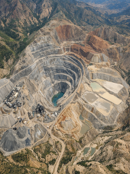
How Satellite Imagery Supports Mining Monitoring
Satellite technology enables large-scale observation of mining regions and provides detailed insights into mining operations. With high-resolution satellite imagery and remote sensing data, analysts can detect even small changes in terrain, land cover, and infrastructure development.
Detecting Illegal Mining Activities
Illegal mining is a major challenge in many countries. Unauthorized extraction not only causes economic losses but also leads to severe environmental damage.
Using satellite imagery analysis, authorities can identify:
- Newly formed excavation pits
- Expansion of mining areas
- Unauthorized road construction
- Illegal settlement growth near mining zones
Frequent satellite monitoring allows authorities to detect these activities early and take corrective action.
Monitoring Mining Expansion
Mining operations evolve rapidly as companies expand excavation zones, build infrastructure, and modify landscapes.
Multi-temporal satellite imagery allows analysts to compare satellite images over time and detect changes such as:
- Expansion of open pit mines
- Waste dump growth
- Tailings dam development
- Infrastructure construction
These insights help regulators ensure mining activities comply with approved land-use plans and environmental guidelines.
Environmental Impact Monitoring
Mining operations often have significant environmental consequences, including deforestation, land degradation, and water pollution.
Using satellite imagery for environmental monitoring, organizations can track:
- Vegetation loss around mining sites
- River sedimentation caused by mining waste
- Changes in water bodies near mining areas
- Dust pollution and land surface changes
Remote sensing data enables environmental agencies to assess long-term ecological impacts and enforce sustainability standards.
Land Deformation and Subsidence Monitoring
Mining can cause ground instability and land subsidence, especially in underground mining operations.
Using Synthetic Aperture Radar (SAR) satellite imagery, analysts can detect subtle ground movement through techniques such as InSAR (Interferometric SAR).
This technology helps monitor:
- Surface deformation
- Land displacement
- Structural risks near mining infrastructure
- Subsidence around underground mines
These insights help mining companies improve safety and prevent infrastructure damage.
Resource Exploration and Geological Mapping
Satellite data also plays an important role in mineral exploration and geological mapping. Advanced hyperspectral and multispectral satellite imagery can detect mineral signatures and geological structures.
These technologies allow exploration teams to identify:
- Mineral deposits
- Geological formations
- Alteration zones
- Structural faults
By using satellite-based mineral mapping, companies can narrow down exploration targets before conducting expensive field surveys.
Key Technologies Behind Satellite-Based Mining Analytics
The growing adoption of satellite monitoring in mining is driven by advances in earth observation technologies. High-Resolution Satellite Imagery
Modern commercial satellites provide imagery with resolutions as high as 30–50 cm, enabling analysts to detect small features such as excavation pits, machinery, and roads.
This level of detail supports accurate mining site monitoring.
Synthetic Aperture Radar (SAR)
SAR satellites operate using microwave signals, allowing them to capture images day and night and through clouds.
SAR data is particularly valuable for:
- Land deformation monitoring
- Terrain stability analysis
- Monitoring mining sites in cloudy regions
Geospatial Analytics and GIS
Satellite imagery becomes truly valuable when integrated with GIS platforms and geospatial analytics tools. These systems allow analysts to process satellite data and extract meaningful insights.
GIS platforms enable:
- Land use classification
- Change detection analysis
- Environmental impact mapping
- Infrastructure monitoring
AI and Machine Learning in Mining Monitoring
Artificial intelligence is increasingly used to automate satellite image interpretation.
AI algorithms can automatically detect:
- Mining pits
- Waste dumps
- Land cover changes
- Infrastructure expansion
This significantly reduces the time required for satellite image analysis and improves monitoring efficiency.
Applications Across the Mining Industry
Satellite analytics is widely used across multiple aspects of mining operations.
Operational Monitoring
Mining companies use satellite imagery to monitor operational activities and track site development.
Environmental Compliance
Governments and environmental regulators use satellite monitoring for mining compliance to ensure mining companies follow environmental regulations.
Risk Management
Satellite data helps identify geological risks such as landslides, subsidence, and unstable terrain around mining sites.
Resource Planning
Mining organizations use satellite analytics to plan extraction activities and manage natural resources more efficiently.
The Future of Satellite Monitoring in Mining
The role of satellite technology in mining will continue to grow as new earth observation satellites and geospatial platforms become available.
Future developments include:
- AI-powered satellite monitoring platforms
- Near real-time satellite imagery analysis
- Integration with drone and ground sensors
- Automated mining intelligence dashboards
- Digital twin models of mining sites
These innovations will enable mining companies and governments to monitor natural resources more effectively while minimizing environmental impact.
Conclusion
The mining industry is undergoing a digital transformation driven by advances in satellite imagery, remote sensing, and geospatial analytics. Satellite technology now allows organizations to monitor mining operations, track environmental impact, and manage natural resources with unprecedented accuracy.
From detecting illegal mining activities to monitoring land deformation and environmental change, satellite imagery for mining monitoring provides critical insights that support sustainable resource management.
As satellite data becomes more accessible and analytical tools continue to evolve, satellite-based mining intelligence will play an increasingly important role in responsible mining operations and natural resource monitoring worldwide.


