Urban Planning from Space: How Satellite Imagery is Transforming Modern City Development
Cities are expanding at an unprecedented rate. According to global urban development studies, more than 68% of the world’s population will live in cities by 2050. This rapid urbanization creates enormous pressure on governments, planners, and infrastructure systems. Managing land use, transportation, housing, environmental protection, and public infrastructure has become significantly more complex than ever before.
Traditional urban planning methods relied heavily on field surveys, manual land records, and outdated mapping systems. While these approaches were effective decades ago, they struggle to keep up with the fast pace of modern urban expansion. This is where satellite imagery for urban planning is transforming the way cities understand, monitor, and manage growth.
By leveraging Earth observation data and geospatial intelligence, planners can monitor urban expansion, identify land-use changes, detect illegal constructions, and make data-driven decisions for sustainable city development.
The Rise of Satellite-Based Urban Intelligence
Satellite imagery has evolved into one of the most powerful tools in modern geospatial analysis. Earth observation satellites continuously capture high-resolution images of the planet, enabling governments and planners to analyze urban environments with remarkable accuracy.
Urban planning teams use different types of satellite data to gain a comprehensive view of city development:
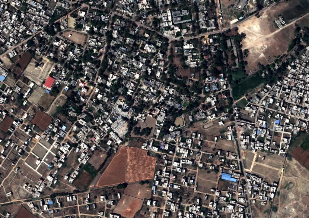
Optical satellite imagery provides detailed visual representations of urban landscapes, roads, buildings, and vegetation. These images are widely used for mapping and monitoring city infrastructure.
Synthetic Aperture Radar (SAR) satellites can capture data regardless of weather or lighting conditions. SAR technology is extremely valuable for monitoring urban areas during cloudy conditions or at night.
Multispectral satellite imagery analyzes different wavelengths of light to identify land-use categories such as residential zones, industrial areas, vegetation, and water bodies.
Night-time light satellite data helps planners understand economic activity, energy usage patterns, and urban density across metropolitan regions.
When integrated with Geographic Information Systems (GIS) and advanced geospatial analytics platforms, satellite imagery becomes a powerful decision-support system for urban planners.
Instead of relying on outdated maps, planners now have access to real-time spatial intelligence that reflects the true state of city growth.
Monitoring Urban Expansion and Land Use
One of the most important applications of satellite imagery for urban planning is monitoring urban expansion. Cities often grow faster than their infrastructure systems can handle, leading to traffic congestion, housing shortages, and environmental degradation.
Satellite-based monitoring allows planners to track urban sprawl and land-use change over time using multi-temporal imagery. By comparing satellite images captured across months or years, analysts can detect:
- Expansion of residential and commercial areas
- Conversion of agricultural land into urban settlements
- Encroachment on protected land or green zones
- Growth of informal settlements and slums
- Unplanned infrastructure development
These insights enable governments to update zoning policies, enforce regulations, and guide sustainable land development strategies.
For example, satellite data can quickly reveal whether construction activity is happening outside approved development zones, helping authorities detect illegal land encroachment or unauthorized construction projects.
Infrastructure Planning and Smart City Development
Modern cities require complex infrastructure networks including roads, transportation systems, utilities, and housing developments. Satellite imagery provides planners with large-scale visibility of urban infrastructure, making it easier to design and optimize these systems.
Using geospatial analytics and satellite imagery, city planners can analyze transportation networks, evaluate road congestion patterns, and identify optimal routes for future infrastructure development.
Satellite-based planning supports:
- Transportation corridor planning
- Highway and railway network development
- Urban housing expansion analysis
- Utility infrastructure planning
- Smart city development projects
Satellite data also helps planners evaluate urban density patterns, allowing governments to design cities that are more efficient, connected, and livable.
In smart city initiatives, satellite intelligence is often integrated with IoT sensors, traffic data, and urban dashboards to create data-driven urban governance systems.
Environmental Monitoring and Urban Sustainability
Urban development can significantly impact the environment if not managed carefully. Rapid construction often leads to deforestation, water pollution, reduced green spaces, and increased flood risks.
Satellite imagery allows planners to monitor environmental indicators across entire metropolitan regions.
Urban environmental monitoring using satellite data includes:
- Mapping urban green spaces and vegetation cover
- Monitoring lakes, rivers, and urban water bodies
- Identifying flood-prone zones and drainage patterns
- Detecting air pollution and heat island effects
- Monitoring environmental compliance of construction projects
By analyzing these factors, planners can implement policies that protect ecosystems while supporting economic growth.
For instance, satellite imagery can reveal how excessive construction reduces vegetation cover, allowing planners to introduce green urban development policies.
Disaster Risk Planning and Urban Resilience
Cities located in coastal regions, seismic zones, or flood-prone areas face increasing disaster risks. Satellite imagery plays a critical role in urban disaster risk management and resilience planning.
Using satellite data, authorities can identify vulnerable areas that may be exposed to flooding, landslides, earthquakes, or storm surges.
Urban planners use satellite intelligence to:
- Map flood risk zones
- Monitor coastal erosion in coastal cities
- Assess earthquake damage in dense urban areas
- Track post-disaster urban recovery
- Plan emergency evacuation routes
During disasters, satellite imagery provides rapid situational awareness that helps emergency response teams coordinate relief operations efficiently.
The Future of Urban Planning with Satellite Data
The future of urban planning is becoming increasingly data-driven. Emerging technologies are transforming satellite imagery into even more powerful tools for city governance.
Artificial intelligence and machine learning are enabling automated urban mapping and change detection, significantly reducing the time required for large-scale spatial analysis.
Another emerging trend is the development of digital twins of cities, where satellite imagery, GIS data, and real-time sensors are combined to create dynamic 3D models of urban environments.
These digital models allow planners to simulate development scenarios, evaluate infrastructure investments, and test climate resilience strategies before implementing policies.
Additionally, the increasing availability of high-resolution commercial satellite imagery is making geospatial intelligence accessible to more governments, private organizations, and urban planners worldwide.
As cities continue to grow, satellite imagery for urban planning will become an essential foundation for smart, sustainable, and resilient urban development.
Conclusion
Urbanization is accelerating across the world, creating new challenges for planners, governments, and infrastructure systems. Traditional planning methods alone cannot keep pace with the complexity and scale of modern cities.
Satellite imagery provides a powerful solution by delivering accurate, scalable, and continuously updated spatial intelligence.
From monitoring urban expansion and infrastructure development to managing environmental sustainability and disaster risk, Earth observation data is transforming urban planning practices.
Cities that embrace satellite-based geospatial intelligence will be better equipped to build smarter infrastructure, manage land resources efficiently, and create sustainable urban environments for future generations.
In the coming decades, urban planning from space will become one of the most critical tools shaping the cities of tomorrow.


