How Satellite Imagery is Transforming Climate Risk, ESG, and Sustainability Reporting
Environmental responsibility is no longer optional for businesses and governments. Climate change, environmental degradation, and global sustainability challenges are forcing organizations to adopt stronger environmental governance practices. Investors, regulators, and stakeholders now expect transparent reporting on environmental impact, climate risks, and sustainability performance.
This is where satellite imagery for ESG reporting is becoming an essential tool. By leveraging satellite imagery and Earth observation data, organizations can monitor environmental conditions across large geographic areas, assess climate risks, and generate reliable sustainability reports backed by real-world data.
Satellite-based monitoring provides objective, scalable, and verifiable environmental intelligence that supports modern Environmental, Social, and Governance (ESG) frameworks.
The Growing Importance of ESG and Climate Risk Reporting
Over the past decade, ESG reporting has become a critical component of corporate accountability. Global investors are increasingly prioritizing companies that demonstrate strong environmental stewardship and transparent sustainability practices.
Organizations today must report on key environmental indicators such as:
- Carbon emissions
- Deforestation impact
- Water resource management
- Land-use changes
- Climate risk exposure
- Biodiversity protection
However, collecting accurate environmental data using traditional methods can be expensive, time-consuming, and geographically limited.
Field surveys and manual reporting often fail to capture environmental changes occurring across large territories. This limitation creates gaps in sustainability reporting and makes it difficult to verify environmental claims.
By integrating satellite imagery for ESG reporting, organizations can obtain continuous, large-scale environmental insights that support credible and data-driven sustainability disclosures.
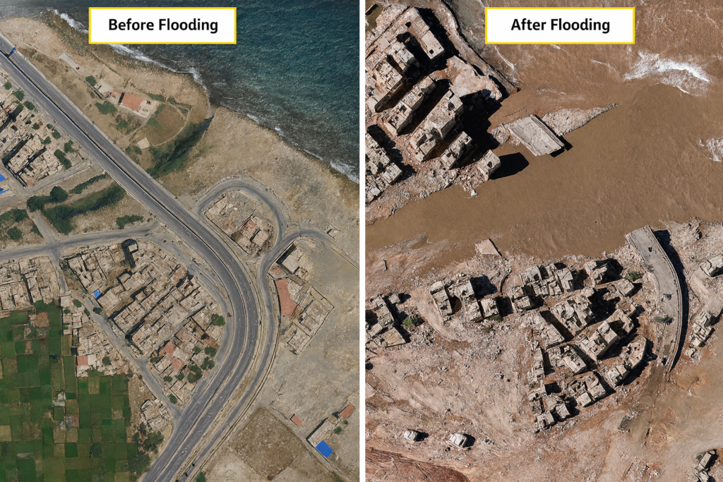
Monitoring Climate Risk with Satellite Intelligence
Climate change is introducing new risks that affect infrastructure, agriculture, supply chains, and urban environments. Businesses and governments must evaluate how climate-related hazards could impact operations, assets, and investments.
Satellite imagery provides valuable information for climate risk assessment and monitoring.
Using Earth observation data, analysts can track:
- Rising sea levels in coastal regions
- Flood-prone areas and river basin changes
- Drought patterns and soil moisture levels
- Glacial retreat and snow cover changes
- Wildfire activity and forest degradation
These insights help organizations understand potential climate vulnerabilities and prepare mitigation strategies.
For example, satellite imagery can reveal long-term coastal erosion patterns, allowing infrastructure planners to design climate-resilient coastal projects. Similarly, satellite monitoring of drought conditions can help agricultural companies anticipate supply chain disruptions.
This type of satellite-based climate intelligence allows decision-makers to incorporate environmental risks into long-term planning and sustainability strategies.
Satellite Monitoring for Environmental Impact Assessment
Satellite imagery plays a major role in evaluating environmental impact across industries such as mining, infrastructure development, energy, and agriculture.
Organizations can use satellite data to monitor environmental indicators such as:
- Land degradation caused by industrial activities
- Deforestation near mining or infrastructure projects
- Water pollution and sedimentation patterns
- Vegetation loss due to land-use change
- Habitat fragmentation affecting biodiversity
Because satellites capture imagery regularly, analysts can compare historical images with current observations to identify environmental changes over time.
This capability is extremely valuable for environmental impact assessments (EIA) and sustainability audits.
For example, satellite imagery can help regulators verify whether a mining project is complying with environmental regulations by monitoring vegetation loss and land disturbance near the project site.
Such independent geospatial monitoring strengthens environmental accountability and reduces the risk of inaccurate sustainability reporting.
Strengthening Corporate Sustainability Reporting
Accurate sustainability reporting requires reliable data that can withstand regulatory scrutiny and investor analysis. Satellite imagery provides objective environmental data that enhances transparency in ESG disclosures.
Organizations can integrate satellite-based insights into their sustainability reports to support claims related to:
- Forest conservation initiatives
- Carbon offset projects
- Renewable energy infrastructure monitoring
- Sustainable land management practices
- Environmental restoration projects
For example, companies involved in carbon offset programs can use satellite imagery to verify reforestation progress and measure vegetation growth over time.
Similarly, renewable energy companies can monitor solar farms, wind farms, and hydroelectric infrastructure using satellite imagery to track environmental performance.
By incorporating satellite imagery for ESG reporting, companies strengthen the credibility of their sustainability claims while providing stakeholders with verifiable environmental evidence.
Supporting Government Sustainability Policies
Governments and regulatory bodies are also increasingly using satellite imagery to support environmental governance and climate policy implementation.
Satellite monitoring allows governments to oversee environmental conditions across entire countries without relying solely on ground inspections.
Key applications include:
- Monitoring illegal deforestation
- Tracking wetland degradation
- Identifying land-use violations
- Monitoring protected ecosystems
- Assessing carbon sequestration programs
Satellite imagery enables governments to enforce environmental regulations more effectively while ensuring transparency in climate policy implementation.
For example, satellite monitoring can detect unauthorized logging activity in protected forests or identify land-use violations in environmentally sensitive zones.
This capability strengthens environmental governance and supports national climate commitments under global frameworks.
The Future of Satellite-Based ESG Intelligence
Advancements in geospatial technologies are making satellite-based ESG monitoring even more powerful.
Artificial intelligence and machine learning are enabling automated analysis of large volumes of satellite imagery, allowing analysts to detect environmental changes faster and with greater accuracy.
Future innovations include:
- AI-powered climate risk modeling
- Automated deforestation detection systems
- Satellite-based carbon monitoring
- Integration of satellite data with ESG analytics platforms
- Real-time environmental intelligence dashboards
These technologies will allow organizations to move from static sustainability reports to continuous environmental monitoring systems.
As climate risks intensify and ESG regulations become stricter, satellite imagery will play an increasingly central role in environmental transparency and sustainable governance.
Conclusion
Climate change and environmental responsibility are reshaping the way organizations operate and report their impact. Investors, regulators, and the public expect credible and transparent sustainability reporting supported by reliable data.
Satellite imagery provides a powerful solution by delivering objective, large-scale environmental intelligence that supports climate risk assessment, environmental monitoring, and ESG reporting.
From tracking deforestation and water resources to evaluating climate risks and verifying sustainability projects, satellite imagery for ESG reporting is becoming a critical tool for modern environmental governance.
Organizations that integrate satellite-based geospatial intelligence into their sustainability strategies will be better equipped to manage climate risks, meet regulatory expectations, and demonstrate meaningful environmental stewardship.
In the evolving landscape of sustainability and climate accountability, satellite imagery is rapidly becoming a cornerstone of credible ESG reporting and environmental decision-making.


