Automated Change Detection Using Satellite Imagery
The Earth’s surface is constantly evolving. Cities expand, forests shrink, rivers change course, and new infrastructure appears almost daily. Monitoring these changes across large geographic areas has always been a challenge for governments, environmental agencies, and industries. Traditional field surveys are slow, expensive, and often unable to keep up with the speed of change.
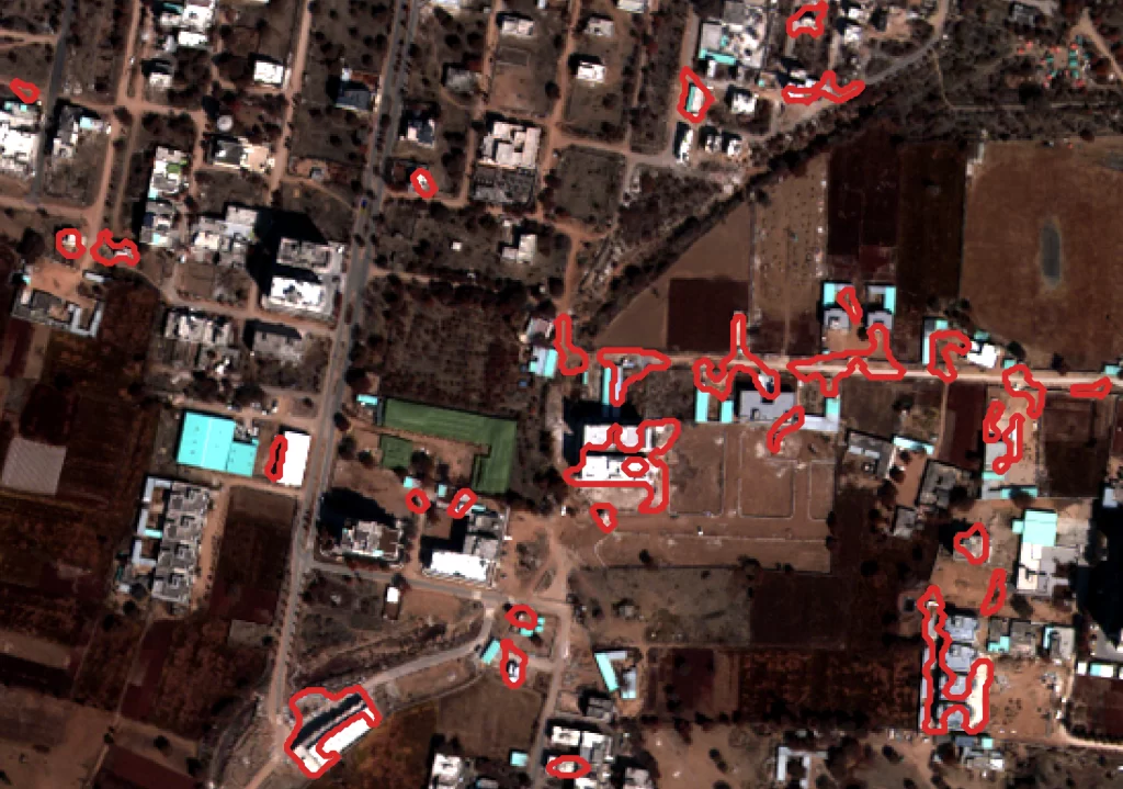
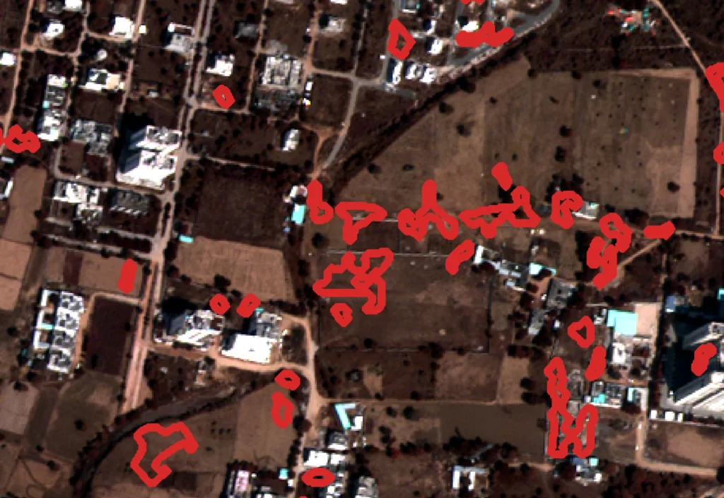
This is where automated change detection using satellite imagery is transforming geospatial intelligence. By analyzing satellite images captured at different time intervals, advanced algorithms can automatically identify changes on the Earth’s surface. From urban development and infrastructure expansion to environmental degradation and disaster impact, satellite-based change detection provides critical insights for decision-makers.
With the integration of artificial intelligence, geospatial analytics, and satellite image processing, automated change detection is becoming a powerful tool for monitoring our planet in near real-time.
What is Automated Change Detection?
Automated change detection is a geospatial analysis technique that identifies differences between satellite images captured at different times. These differences reveal how land cover, infrastructure, vegetation, and natural landscapes evolve over time.
Using satellite imagery analysis and machine learning algorithms, geospatial systems compare historical satellite images with recent imagery to detect variations in features such as:
- Urban expansion and construction activity
- Deforestation and vegetation loss
- Coastal erosion and shoreline shifts
- Mining and land excavation activities
- Agricultural land-use changes
- Infrastructure development
Unlike manual interpretation of satellite images, automated systems can process thousands of images quickly and highlight areas where significant changes have occurred.
This capability enables governments and organizations to monitor large territories efficiently while gaining faster insights into land-use changes.
How Satellite Imagery Enables Change Detection
Satellite imagery provides a consistent and repeatable view of the Earth’s surface. Modern Earth observation satellites capture images of the same location regularly, sometimes every few days. This repeated observation allows analysts to track changes over time.
Several types of satellite data support automated change detection using satellite imagery:
Optical Satellite Imagery
Optical satellites capture images similar to photographs taken from space. These images are useful for detecting visible changes such as new buildings, roads, deforestation, and urban expansion.
Multispectral Satellite Data
Multispectral imagery captures multiple wavelengths of light, allowing analysts to detect changes in vegetation health, soil conditions, and water bodies.
Synthetic Aperture Radar (SAR)
SAR satellites can capture imagery regardless of cloud cover or lighting conditions. This makes them especially useful for monitoring flood events, land deformation, and infrastructure changes.
By comparing multi-temporal satellite images from these sensors, geospatial systems can detect subtle or large-scale changes in landscapes.
The Role of AI and Machine Learning in Change Detection
The rapid growth of satellite data has made manual image interpretation impractical. Today, artificial intelligence and machine learning algorithms are used to automate change detection processes.
AI models analyze satellite imagery by identifying patterns, textures, and spectral signatures associated with different land features. When new imagery becomes available, the system compares it with previous images and automatically highlights areas where changes have occurred.
These systems can detect:
- New construction activity in urban areas
- Illegal deforestation in protected forests
- Expansion of mining operations
- Agricultural land-use transitions
- Environmental damage caused by disasters
Machine learning models continuously improve as they process more satellite imagery, making automated detection systems increasingly accurate and reliable.
This combination of AI-powered satellite image analysis and geospatial intelligence enables faster and more scalable monitoring of the Earth’s surface.
Applications of Automated Change Detection
Automated change detection using satellite imagery is widely used across industries and government sectors.
Urban Development Monitoring
Urban planners use satellite imagery to monitor city expansion, track new infrastructure development, and detect unauthorized construction activities. This helps authorities manage zoning regulations and plan future urban growth.
Environmental Monitoring
Environmental agencies rely on satellite change detection to track deforestation, habitat loss, desertification, and wetland degradation. This helps governments enforce environmental protection policies.
Disaster Impact Assessment
After natural disasters such as earthquakes, floods, or hurricanes, satellite change detection can quickly identify damaged infrastructure and affected regions. Emergency response teams can use this information to prioritize rescue and recovery efforts.
Mining and Resource Monitoring
Mining companies and regulators use satellite imagery to track excavation activity, land disturbance, and environmental impact around mining sites.
Agriculture Monitoring
Satellite change detection allows analysts to observe crop patterns, irrigation expansion, and seasonal agricultural changes across large farmland areas.
These applications demonstrate how satellite imagery analysis and automated geospatial monitoring can support faster and more informed decision-making.
Benefits of Automated Satellite Change Detection
The adoption of automated change detection systems offers several advantages compared to traditional monitoring methods.
Large-Scale Monitoring
Satellite imagery can cover vast geographic areas, enabling continuous monitoring of entire countries or regions.
Frequent Updates
Modern Earth observation satellites provide imagery at regular intervals, allowing analysts to track changes over days, weeks, or months.
Faster Analysis
AI-powered geospatial systems can process massive volumes of satellite data quickly, significantly reducing analysis time.
Objective Data
Satellite imagery provides unbiased observations that improve transparency in environmental monitoring and land management.
Historical Analysis
Satellite archives allow analysts to study land-use changes over decades, helping researchers understand long-term environmental trends.
These benefits make automated change detection using satellite imagery a critical capability for modern geospatial intelligence systems.
Future Trends in Satellite Change Detection
The future of satellite-based monitoring is rapidly evolving with advancements in technology.
Emerging innovations include:
- Real-time satellite monitoring systems
- AI-powered geospatial analytics platforms
- Integration with cloud-based GIS platforms
- High-frequency satellite constellations
- Automated environmental alert systems
With the increasing availability of high-resolution satellite imagery and powerful machine learning tools, change detection systems will become faster, more accurate, and more accessible.
Organizations will soon be able to monitor environmental and urban changes continuously through automated dashboards that deliver near real-time insights.
Conclusion
Monitoring how the Earth’s surface changes over time is essential for sustainable development, environmental protection, and infrastructure planning. Traditional surveying methods cannot keep up with the scale and speed of global changes.
Automated change detection using satellite imagery provides a scalable and efficient solution by combining Earth observation data, geospatial analytics, and artificial intelligence.
From tracking urban expansion and deforestation to assessing disaster damage and monitoring industrial activity, satellite-based change detection enables organizations to identify critical changes quickly and accurately.
As satellite technology continues to advance, automated change detection will play an increasingly important role in geospatial intelligence, environmental monitoring, and data-driven decision-making across industries worldwide.


