.png)


.png)
.png)


.png)


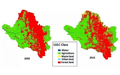
Mining has been a cornerstone of human progress for millennia, providing essential resources that power our modern world. However, the extraction of these valuable minerals and ores often comes at a cost, with environmental and safety concerns looming large. As society places increasing emphasis on sustainability, the mining industry finds itself at a crossroads, seeking… Continue reading Unearthing the Future: The Vital Role of Remote Sensing and GIS in Mining