Remote Sensing in Disaster Management: Applications and Real-World Use
Natural disasters have become increasingly frequent, complex, and costly across the globe. Floods, earthquakes, wildfires, cyclones, landslides, and droughts impact millions of people every year, often causing significant damage to infrastructure, economies, and ecosystems. As disaster risks continue to grow due to climate change, rapid urbanization, and environmental degradation, governments and organizations are seeking more effective ways to prepare for, respond to, and recover from disasters.
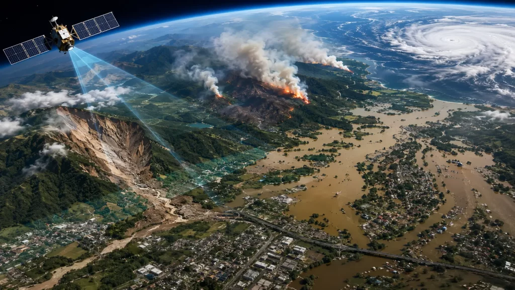
One of the most powerful technologies supporting modern disaster management is remote sensing. Through satellites, aircraft, drones, and other sensor platforms, remote sensing provides timely and accurate information about the Earth’s surface without requiring direct physical contact. The growing use of satellite imagery and geospatial intelligence has transformed how disaster managers monitor hazards, assess risks, coordinate emergency responses, and support recovery efforts.
Today, remote sensing in disaster management plays a critical role throughout the entire disaster lifecycle, enabling decision-makers to move from reactive response strategies to proactive risk management approaches.
Understanding the Role of Remote Sensing in Disaster Management
The role of remote sensing in disaster management extends far beyond capturing satellite images. Remote sensing technologies provide a continuous stream of spatial information that helps authorities understand changing environmental conditions before, during, and after disasters occur.
Remote sensing systems collect data using sensors mounted on satellites, aircraft, drones, and other platforms. These sensors detect reflected or emitted energy from the Earth’s surface and convert it into valuable information for analysis. Depending on the sensor type, remote sensing data can capture details about vegetation, land use, water bodies, infrastructure, temperature, moisture levels, and terrain characteristics.
One of the key advantages of remote sensing is its ability to cover large geographic areas quickly. During major disasters, ground surveys may be difficult, dangerous, or impossible to conduct. Satellite imagery provides a safe and efficient alternative, allowing emergency responders to gain situational awareness even in inaccessible regions.
Remote sensing also enables frequent monitoring of changing conditions. Modern Earth observation satellites can revisit the same location multiple times within days or even hours, providing near real-time insights that support critical decision-making.
This capability has made remote sensing a cornerstone of disaster risk reduction and emergency management programs worldwide.
Application of Remote Sensing in Disaster Management
The application of remote sensing in disaster management spans all phases of disaster management, including preparedness, mitigation, response, and recovery.
Before disasters occur, remote sensing helps identify vulnerable areas and assess potential hazards. By analyzing historical imagery, environmental conditions, and land-use patterns, authorities can develop strategies to reduce disaster risks and improve preparedness.
During a disaster event, remote sensing provides rapid information that supports emergency response operations. Satellite imagery can identify flooded regions, wildfire boundaries, damaged infrastructure, blocked transportation routes, and affected populations. These insights enable emergency teams to prioritize resources and coordinate relief efforts more effectively.
Following a disaster, remote sensing plays a vital role in damage assessment and recovery planning. High-resolution imagery allows organizations to evaluate the extent of destruction, estimate economic losses, and monitor reconstruction progress over time.
Remote sensing is also widely used in disaster simulation and predictive modeling. By combining satellite data with GIS and advanced analytics, organizations can forecast potential impacts and develop more resilient disaster management strategies.
The ability to provide timely, accurate, and large-scale information makes remote sensing one of the most valuable tools available for disaster management professionals.
Risk Mapping in Disaster Management: Identifying Vulnerabilities Before Disaster Strikes
Effective disaster management begins with understanding where risks exist. This is where risk mapping in disaster management becomes essential.
Risk mapping involves identifying areas that are vulnerable to specific hazards based on geographic, environmental, social, and economic factors. Remote sensing provides the foundational data required to create accurate risk maps that support disaster preparedness and mitigation planning.
For example, satellite imagery can be used to monitor floodplains, coastal erosion zones, drought-prone regions, wildfire risk areas, and landslide-prone slopes. By integrating this information with population density, infrastructure networks, and socioeconomic data, disaster managers can identify communities that face the highest levels of risk.
Risk maps help governments prioritize investments in disaster resilience, emergency infrastructure, evacuation planning, and public awareness programs. They also support insurance assessments and policy development by providing objective information about hazard exposure.
As climate change continues to alter environmental conditions, remote sensing-based risk mapping is becoming increasingly important for helping communities adapt to emerging threats and reduce future disaster impacts.
Hazard Mapping in Disaster Management and Real-World Applications
While risk mapping focuses on vulnerability, hazard mapping in disaster management focuses on identifying and monitoring the actual hazards that may cause disasters.
Hazard maps are created using remote sensing data to identify areas affected by floods, earthquakes, volcanic activity, wildfires, storms, and other natural hazards. These maps help authorities understand where hazards are likely to occur and how they may evolve over time.
Flood management provides one of the most widely recognized examples of hazard mapping. Satellite imagery can monitor river systems, rainfall patterns, and water accumulation, enabling authorities to predict flooding events and issue early warnings. During flood events, radar satellites can capture imagery even through clouds and darkness, providing critical information when optical imagery may be unavailable.
Wildfire management also relies heavily on remote sensing. Thermal sensors detect active fire hotspots, monitor fire spread, and support firefighting operations. Similarly, earthquake response teams use satellite imagery to assess structural damage and identify affected communities immediately after seismic events.
The 2004 Indian Ocean tsunami, Hurricane Katrina, the 2015 Nepal earthquake, and numerous recent flood disasters worldwide demonstrated how remote sensing technologies can significantly improve disaster response and recovery efforts. Today, governments, humanitarian organizations, and emergency agencies routinely incorporate remote sensing into operational disaster management frameworks.
As satellite technology continues to advance, hazard mapping capabilities are becoming more accurate, timely, and accessible than ever before.
Conclusion
The importance of remote sensing in disaster management continues to grow as the world faces increasingly complex natural and environmental hazards. By providing timely, accurate, and large-scale geographic information, remote sensing enables organizations to improve preparedness, strengthen response efforts, and accelerate recovery operations.
From the application of remote sensing in disaster management to advanced risk mapping in disaster management and hazard mapping in disaster management, geospatial technologies have transformed how disasters are monitored and managed. The ability to observe the Earth’s surface in near real time empowers decision-makers with the information needed to protect lives, reduce losses, and build more resilient communities.
As Earth observation technologies, artificial intelligence, and geospatial analytics continue to evolve, remote sensing will remain at the forefront of disaster risk reduction and emergency management worldwide.
FAQs
Remote sensing in disaster management involves using satellite imagery, aerial imagery, drones, and sensor-based technologies to monitor, assess, and respond to natural and human-induced disasters.
Remote sensing is used for disaster preparedness, hazard identification, risk assessment, emergency response, damage assessment, recovery planning, and long-term resilience building.
Hazard mapping is the process of identifying and monitoring areas prone to natural hazards such as floods, landslides, earthquakes, wildfires, and cyclones using geospatial data and remote sensing technologies.
Risk mapping helps identify vulnerable areas, populations, and infrastructure exposed to hazards, enabling authorities to develop targeted mitigation and preparedness strategies.
Remote sensing provides near real-time information about affected areas, helping emergency responders assess damage, allocate resources, plan evacuations, and coordinate relief efforts efficiently.


