30cm vs 50cm Satellite Imagery: Differences, Use Cases & GSD Explained
High-resolution satellite imagery has become a core component of modern geospatial analysis, enabling organizations to monitor infrastructure, map urban growth, assess environmental change, and support critical decision-making processes. Among the most commonly used commercial resolutions today are 30cm satellite imagery and 50cm satellite imagery.
While both fall under the category of high-resolution Earth observation imagery, they differ significantly in terms of detail, coverage efficiency, processing requirements, and operational use cases.
30cm and 50cm satellite imagery represent two widely used standards of high-resolution Ground Sample Distance (GSD).
30cm imagery delivers finer spatial detail, making it ideal for identifying vehicles, road markings, small infrastructure elements, and property boundaries.
50cm imagery provides broader area coverage at a lower acquisition and processing cost, making it highly effective for regional monitoring, environmental assessments, corridor analysis, and large-scale mapping projects.
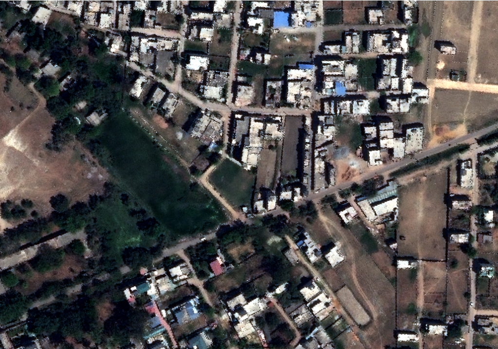
30cm vs 50cm satellite imagery example over urban area showing difference in visible detail
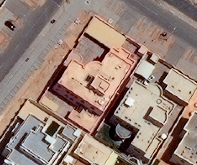
50cm satellite imagery
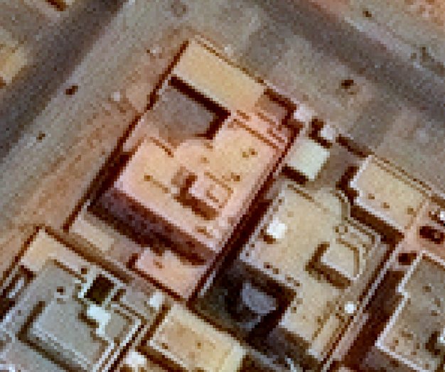
30cm satellite imagery
What is Ground Sample Distance (GSD)?
Ground Sample Distance (GSD) refers to the real-world ground dimension represented by a single pixel in a satellite image. It is one of the most important indicators of satellite imagery resolution and directly determines the level of visible detail.
A smaller GSD means higher spatial resolution and greater image clarity.
- 30cm GSD: One pixel represents 30 cm on the ground.
- 50cm GSD: One pixel represents 50 cm on the ground.
This difference may appear small numerically, but in practical applications, it significantly impacts feature detectability, mapping precision, and analytical capability.
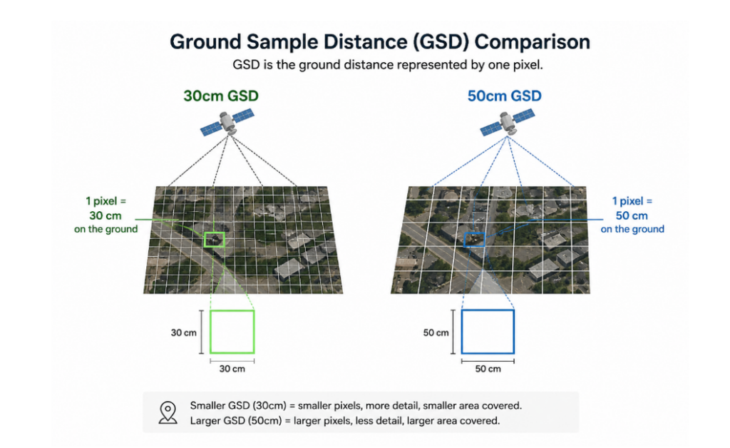
Ground Sample Distance comparison 30cm vs 50cm diagram showing pixel size difference
What is 30cm Satellite Imagery?
30cm satellite imagery is classified as very high-resolution commercial satellite imagery designed for precision mapping and feature-level analysis.
At this resolution, individual urban features become highly distinguishable, enabling advanced geospatial interpretation and accurate infrastructure extraction.
Key Characteristics of 30cm Imagery
- Extremely high spatial resolution
- Superior object detection capability
- Enhanced edge definition and feature separation
- Improved urban feature interpretation
- Better support for AI/ML object detection models
- Higher positional accuracy for mapping applications
Use Cases for 30cm Satellite Imagery
30cm satellite imagery is ideal for dense urban environments where highly accurate extraction of building footprints, road networks, transportation infrastructure, and other fine-scale urban features is required for planning, development, and geospatial analysis.
- Infrastructure Mapping
The high spatial resolution makes it widely suitable for utility corridor mapping, smart city planning, transportation asset inventories, and construction monitoring, where detailed infrastructure visibility and precise feature interpretation are critical.
Property and Parcel Analysis
30cm imagery supports cadastral assessment, land parcel verification, and property boundary interpretation by enabling clearer visualization of small land features and built structures.
- Transportation Monitoring
Its enhanced detail allows accurate identification of vehicles, lane markings, parking layouts, and rail infrastructure, making it valuable for transportation planning, traffic analysis, and mobility studies.
- Disaster Assessment
During disaster response operations, 30cm imagery enables rapid assessment of damaged buildings, flood-affected infrastructure, debris accumulation, and urban impact zones, helping authorities improve situational awareness and emergency response planning.
The resolution provides enhanced terrain intelligence and operational situational awareness, supporting defense, surveillance, and security-related geospatial applications that require detailed ground feature visibility.
- AI-Based Object Detection
High-resolution 30cm imagery significantly improves machine learning and AI-based object detection workflows because smaller objects and finer spatial patterns become more distinguishable and accurately detectable.
30cm satellite imagery showing vehicles and road markings
What is 50cm Satellite Imagery?
50cm satellite imagery is considered medium-high resolution imagery optimized for balancing image detail with operational scalability.
Although slightly less detailed than 30cm imagery, it remains highly effective for most commercial, environmental, and regional monitoring workflows.
Key Characteristics of 50cm Imagery
- Wider area coverage
- Lower acquisition costs
- Faster data processing
- Reduced storage requirements
- Efficient for large-area analysis
- Strong balance between detail and scalability
Use Cases for 50cm Satellite Imagery
- Regional Land Monitoring
50cm satellite imagery is highly effective for large-scale regional monitoring applications, including urban expansion analysis, deforestation tracking, coastal change assessment, and land-use transformation studies, where broad area coverage and consistent temporal monitoring are essential.
- Agriculture and Crop Monitoring
In agricultural applications, 50cm imagery supports crop pattern analysis, irrigation monitoring, field boundary extraction, and vegetation assessment, enabling efficient farm management and large-area agricultural intelligence generation.
- Pipeline and Corridor Monitoring
The resolution is widely used for monitoring linear infrastructure such as oil & gas pipelines, railway corridors, highways, and transmission lines, helping organizations detect encroachments, environmental impacts, and infrastructure changes across extensive corridors.
- Environmental Monitoring
50cm satellite imagery is suitable for environmental and ecological studies, including wetland mapping, watershed assessment, forest monitoring, and habitat analysis, where regional-scale observations are more important than ultra-fine object detection.
- Disaster Response
During natural disasters, 50cm imagery enables rapid large-scale assessment of floods, wildfires, storms, and other hazard events by providing timely situational awareness across extensive geographic regions.
- Base Mapping
It is also commonly used for generating regional orthomosaics, national base maps, and large-area geospatial datasets due to its balance between spatial detail, processing efficiency, and coverage scalability.
50cm satellite imagery showing large area coverage for regional analysis
| Parameter | 30cm Imagery | 50cm Imagery |
|---|---|---|
Ground Sample Distance | 0.30 meters | 0.50 meters |
Spatial Detail | Very High | High |
Small Object Detection | Excellent | Moderate |
Area Coverage Efficiency | Lower | Higher |
Processing Requirements | Higher | Lower |
Storage Requirements | Larger | Relatively Smaller |
Cost | Higher | More economical |
Best Application Scale | Local / Urban | Regional / Large Area |
Infrastructure Visibility | Highly detailed | Generalized |
AI Object Detection Accuracy | Higher | Moderate |
Which Should You Choose?
The choice between 30cm and 50cm satellite imagery depends entirely on the operational objective, required mapping precision, project scale, and budget.
Choose 30cm Satellite Imagery for Detailed Analysis
30cm imagery is best when projects require:
- Precise infrastructure extraction
- Urban feature identification
- Engineering-grade interpretation
- Small object detection
- High-accuracy change detection
- Smart city planning
- Asset-level monitoring
Choose 50cm Satellite Imagery for Coverage and Scalability
50cm imagery is more suitable when:
- Large geographic areas must be monitored
- Budget efficiency is important
- Regional analysis is the priority
- Rapid processing workflows are required
- Moderate detail is sufficient
Why Spatial Resolution Matters in Remote Sensing
Spatial resolution directly influences:
- Feature detectability
- Classification accuracy
- Mapping precision
- Change detection reliability
- AI model performance
- Orthorectification quality
Higher-resolution imagery improves analytical accuracy but increases operational complexity and data volumes. Therefore, selecting the correct GSD is a strategic balance between detail, scalability, and cost.
FAQs
30cm satellite imagery is primarily used for:
- Urban mapping
- Infrastructure analysis
- Transportation monitoring
- Asset extraction
- High-precision geospatial intelligence
Its fine spatial resolution allows detailed interpretation of small ground features.
Yes. 50cm imagery is widely used for:
- Regional monitoring
- Environmental assessments
- Agricultural analysis
- Corridor monitoring
- Large-scale mapping projects
It provides an effective balance between image quality and operational efficiency.
Neither is universally better. The ideal choice depends on project requirements.
- Choose 30cm imagery when maximum detail and precision are required.
- Choose 50cm imagery when broader coverage and cost efficiency are more important.
Conclusion
Both 30cm and 50cm satellite imagery play critical roles in modern Earth observation and remote sensing workflows.
Understanding the relationship between Ground Sample Distance (GSD), spatial resolution, and operational requirements helps organizations select the most effective imagery for their analytical goals, budget, and project scale.
Sanchita Maitri
GIS Engineer


