Remote Sensing in Forestry: Monitoring, Mapping, and Conservation
Forests are among the most valuable natural resources on Earth. They regulate climate, support biodiversity, store carbon, protect watersheds, prevent soil degradation, and provide livelihoods for millions of people worldwide. However, forests face increasing pressure from deforestation, urban expansion, illegal logging, wildfires, mining activities, and climate change. Managing these challenges requires accurate and timely information about forest conditions, something that traditional ground surveys alone cannot provide at a large scale.
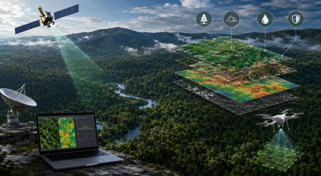
This is where remote sensing has transformed modern forestry management. By utilizing satellite imagery, aerial surveys, drones, LiDAR, and advanced geospatial technologies, forestry professionals can monitor vast forested landscapes efficiently and consistently. The growing application of remote sensing in forestry has enabled governments, conservation organizations, researchers, and forest managers to track changes in forest cover, identify environmental threats, assess ecosystem health, and support sustainable forest management practices.
Today, remote sensing plays a critical role in balancing economic development with environmental conservation. As climate change and ecological challenges continue to intensify, the importance of geospatial technologies in forestry will only continue to grow.
Application of Remote Sensing in Forestry and Forest Resource Management
The application of remote sensing in forestry extends across nearly every aspect of forest management and conservation. Satellite imagery provides a comprehensive view of forest ecosystems, enabling decision-makers to monitor areas that would otherwise be difficult, expensive, or impossible to survey regularly.
One of the most common applications is forest inventory management. Governments and forestry agencies use satellite imagery to estimate forest extent, tree density, species distribution, biomass, and carbon storage. These datasets help support sustainable harvesting plans and long-term resource management strategies.
Remote sensing is also widely used to monitor forest health. Multispectral and hyperspectral imagery can detect subtle changes in vegetation conditions that indicate disease outbreaks, pest infestations, drought stress, or nutrient deficiencies. By identifying these issues early, forest managers can take corrective actions before significant damage occurs.
Wildfire management has become another critical area where remote sensing provides valuable insights. Satellite sensors can detect active fire hotspots, monitor fire progression, and assess post-fire damage. This information supports emergency response efforts and helps agencies evaluate ecological impacts after wildfire events.
As Earth observation technologies continue to advance, forestry professionals are increasingly relying on remote sensing to make informed decisions based on accurate and up-to-date geospatial intelligence.
Understanding the Effects of Deforestation Through Satellite Imagery
One of the most important contributions of remote sensing is its ability to visualize and quantify forest loss over time. The widespread availability of effects of deforestation images has significantly improved public awareness and scientific understanding of environmental degradation.
Satellite imagery enables analysts to compare forest conditions across multiple years and identify areas experiencing rapid deforestation. These visual records reveal the scale and speed at which forests are being cleared for agriculture, infrastructure development, mining operations, and urban expansion.
The environmental impacts of deforestation are extensive. Forest loss reduces biodiversity, disrupts wildlife habitats, contributes to greenhouse gas emissions, alters local weather patterns, and increases vulnerability to natural disasters such as floods and landslides. Satellite imagery provides objective evidence that helps policymakers, environmental organizations, and researchers assess these impacts and develop mitigation strategies.
Global forest monitoring initiatives frequently use remote sensing to track deforestation trends in critical ecosystems such as the Amazon rainforest, Southeast Asian tropical forests, and African woodland regions. The ability to produce near real-time deforestation alerts has become a powerful tool in combating illegal logging and promoting sustainable land-use practices.
By transforming complex environmental changes into easily understandable visual information, remote sensing has become an essential instrument for forest conservation and environmental governance.
Monitoring Climate Change: Forests, Melting Glaciers, and Environmental Change
Forests and glaciers are among the most important indicators of climate change, and remote sensing plays a crucial role in monitoring both. The increasing availability of melting glaciers images captured through satellite observations has provided compelling evidence of global warming and its environmental consequences.
Satellite imagery allows scientists to measure glacier retreat, changes in snow cover, and variations in ice thickness over time. These observations help researchers understand the relationship between climate change, water availability, and ecosystem health.
Forests are closely connected to these environmental processes. Healthy forests act as carbon sinks, absorbing carbon dioxide from the atmosphere and helping regulate global climate systems. Deforestation weakens this natural carbon storage capacity, accelerating climate-related impacts.
Remote sensing enables integrated monitoring of forests, glaciers, water resources, and land-use changes within a single analytical framework. This comprehensive perspective helps governments and environmental organizations assess climate risks and develop adaptation strategies.
The combination of forest monitoring and glacier observation demonstrates how remote sensing supports a broader understanding of environmental systems and their interconnected dynamics.
Forest Mapping, Soil Conservation, and Landscape Monitoring
Accurate forest mapping forms the foundation of effective conservation planning. Remote sensing technologies provide detailed geographic information that supports habitat protection, biodiversity assessments, watershed management, and ecosystem restoration efforts.
Different types of forest pictures generated through satellite imagery serve various analytical purposes. Optical imagery provides visually intuitive representations of forest cover, while multispectral imagery reveals vegetation conditions and ecosystem health. LiDAR data offers three-dimensional information about forest structure, canopy height, and biomass distribution.
Remote sensing also plays an important role in monitoring land degradation and soil stability. In many regions, deforestation contributes directly to erosion by removing vegetation that protects the soil from rainfall and surface runoff.
The use of a soil erosion in India map generated through satellite analysis has become increasingly important for identifying vulnerable landscapes and supporting land management initiatives. Areas experiencing severe erosion can be prioritized for reforestation, watershed restoration, and sustainable land-use planning.
By integrating forestry data with soil, hydrology, and topographic information, remote sensing provides a holistic view of environmental conditions and helps support long-term ecological sustainability.
The Future of Forestry Conservation Through Geospatial Technologies
The future of forestry management is increasingly dependent on advanced geospatial technologies. Artificial intelligence, machine learning, cloud computing, drone mapping, and high-resolution satellite constellations are transforming how forests are monitored and protected.
Modern remote sensing platforms can automatically detect illegal logging activities, identify changes in forest cover, estimate carbon stocks, and predict areas at risk of degradation. These capabilities significantly improve the efficiency of conservation programs and environmental monitoring efforts.
Governments worldwide are integrating remote sensing into national forest monitoring systems to support climate commitments, biodiversity protection initiatives, and sustainable development goals. International programs such as REDD+ rely heavily on satellite-based monitoring to evaluate forest conservation outcomes and carbon reduction efforts.
As technology continues to advance, the application of remote sensing in forestry will become even more accurate, accessible, and impactful. This evolution will play a vital role in protecting forests and ensuring their continued contribution to ecological stability and human well-being.
Conclusion
The growing application of remote sensing in forestry has fundamentally transformed how forests are monitored, managed, and conserved. From tracking forest health and analyzing the effects of deforestation images to studying melting glaciers images and creating detailed forest maps, remote sensing provides critical insights that support environmental decision-making.
Advanced Earth observation technologies allow organizations to monitor forests at local, national, and global scales while improving conservation outcomes and promoting sustainable resource management. Whether through analyzing different types of forest pictures or assessing land degradation using a soil erosion in India map, remote sensing continues to provide valuable tools for addressing some of the most pressing environmental challenges of our time.
As climate change and ecosystem pressures intensify, geospatial technologies will remain essential for safeguarding forests and preserving the environmental services they provide.
FAQs
Remote sensing in forestry is used for forest inventory, forest health monitoring, wildfire detection, biodiversity assessment, carbon stock estimation, and conservation planning.
Satellite imagery allows analysts to compare forest cover over time, identify areas of forest loss, monitor illegal logging activities, and assess environmental impacts.
Remote sensing helps scientists track glacier retreat, ice loss, and climate-related environmental changes over large geographic regions with high accuracy.
Common types include optical imagery, multispectral imagery, hyperspectral imagery, thermal imagery, and LiDAR-derived forest maps.
Satellite imagery helps identify erosion-prone regions, monitor land degradation, assess watershed conditions, and support conservation and reforestation initiatives.


