


.png)


.png)
.png)


.png)


Unearthing the Future: The Vital Role of Remote Sensing and GIS in Mining
Mining has been a cornerstone of human progress for millennia, providing essential resources that power our modern world. However, the extraction of these valuable minerals and ores often comes at a cost, with environmental and safety concerns looming large. As society places increasing emphasis on sustainability, the mining industry finds itself at a crossroads, seeking innovative ways to meet the world’s resource demands while minimizing its impact on the environment and ensuring worker safety.
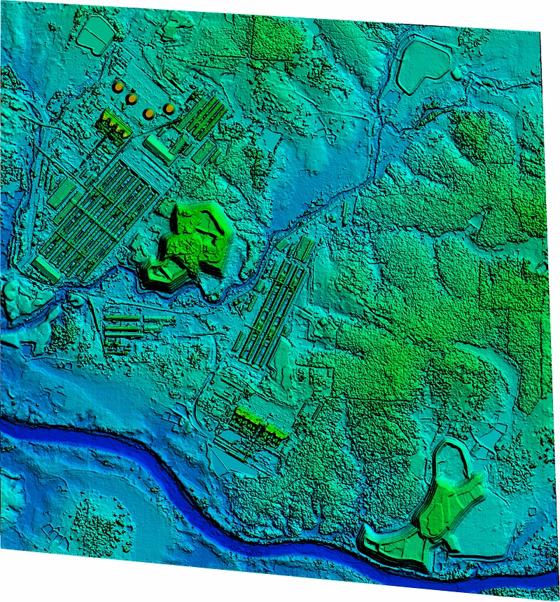
In this context, two powerful technologies have emerged as game-changers for the mining industry: Remote Sensing and Geographic Information Systems (GIS). These cutting-edge tools offer a holistic approach to mining operations, revolutionizing everything from site selection and exploration to safety monitoring and environmental management.
While, delving into the indispensable roles that Remote Sensing and GIS play in reshaping the mining sector and paving the way for a more sustainable and responsible future. Geographic Information Systems (GIS) offer a multifaceted advantage over traditional methods in the mining industry. One of the primary strengths lies in data integration. GIS seamlessly consolidates diverse datasets, including geological, environmental, and spatial data, into a unified platform. This enables comprehensive analysis and decision-making by allowing mining professionals to explore the intricate relationships between various variables.
- Spatial analysis is a compelling aspect where GIS outshines traditional methods. It empowers mining experts to conduct sophisticated spatial operations that would be exceedingly complex or impossible to achieve with conventional techniques. These operations include proximity analysis, buffer zone delineation, overlay analysis, and more. Such capabilities play a pivotal role in optimizing mine design, infrastructure planning, and environmental impact assessment.
- Visualization is another key area where GIS offers a significant advantage. Unlike traditional methods that often rely on static, hand-drawn maps and 2D representations, GIS provides dynamic, three-dimensional visualizations. These dynamic representations make it significantly easier to comprehend complex spatial relationships, facilitating better communication of information to stakeholders.
- Real-time data integration is yet another pivotal strength of GIS. By incorporating data from various sources such as remote sensing, sensors, and GPS tracking, GIS enables mining companies to monitor equipment status, weather conditions, and environmental changes in real time. This real-time monitoring enhances safety protocols and operational efficiency, a feature that traditional methods typically lack due to their reliance on periodic manual data collection.
- When it comes to environmental impact assessment, GIS proves invaluable. It facilitates the monitoring of land cover changes, water quality, and habitat disruption over time, offering a holistic view of environmental alterations caused by mining operations. In contrast, traditional methods may lack the capacity to comprehensively track and assess these changes.
- GIS also shines in decision support, offering powerful tools that leverage spatial data to make informed decisions. Mining companies can simulate various scenarios, assess potential risks and benefits, and ultimately choose the most optimal course of action. Traditional methods, often involving manual calculations and data processing, may not provide the same level of decision support.
- GIS further simplifies regulatory compliance by providing accurate and up-to-date records of mining activities. It streamlines the documentation process, making it easier for mining companies to meet legal requirements and demonstrate compliance with environmental regulations. Traditional methods can be cumbersome, often involving extensive paperwork and documentation.
Further, In the foreseeable future, Geographic Information Systems (GIS) will play a pivotal role in shaping the mining industry, fostering sustainability, efficiency, and responsibility. The integration of Internet of Things (IoT) sensors into mining equipment and operations will provide an influx of real-time data, revolutionizing safety, equipment maintenance, and operational optimization. Simultaneously, immersive 3D and augmented reality (AR) applications, powered by GIS, will redefine how mining professionals perceive and interact with mining sites, enhancing visualization, communication, and on-site safety. The adoption of cloud-based GIS solutions will offer unparalleled scalability and accessibility, ensuring that mining companies, regardless of size, can efficiently manage vast spatial datasets. Furthermore, GIS will expand its role in environmental modeling and simulation, aiding mining companies in proactively predicting and mitigating potential environmental impacts. The integration of blockchain technology will introduce transparency and ethical sourcing into the mining supply chain, assuring consumers and regulators of responsible practices. Collaborative GIS platforms will promote knowledge sharing and cooperative sustainability initiatives among mining companies, driving collective efforts towards a more responsible and sustainable future. In essence, GIS is the compass that will guide the mining industry through the challenges and opportunities of tomorrow, illuminating a path toward responsible resource extraction and environmental stewardship.
In conclusion, the marriage of Remote Sensing and GIS has ushered in a new era of responsible and sustainable mining. These technologies empower mining companies to make informed decisions, reduce environmental footprints, enhance safety, and ensure compliance with regulatory standards. As the mining industry continues to evolve, Remote Sensing and GIS will remain indispensable tools for achieving a balance between resource extraction and environmental conservation.