


.png)


.png)
.png)


.png)


Change Detection: Uncovering Transformations Through High-Resolution Satellite Imagery
In an ever-evolving world, the ability to monitor and analyze changes across various domains is of paramount importance. From tracking environmental transformations to managing urban growth and responding swiftly to disasters, change detection plays a crucial role, and its significance lies in its capacity to uncover shifts, trends, and anomalies that offer critical insights for informed decision-making.
What is change detection?
Change detection is a fundamental process that involves identifying and analyzing differences or alterations in a system, dataset, or environment over time. It is the art of discerning changes, no matter how subtle, that have occurred within a specific timeframe. This process is driven by the need to understand and adapt to evolving situations, making it an indispensable tool across various disciplines.
Change detection can take on many forms, ranging from monitoring land cover changes to changes in vegetation health in agriculture to monitoring crop health, detecting nutrient deficiencies, optimizing resource allocation in remote sensing, and enabling the identification of changes in enemy positions, infrastructure, and activities.
Role of High-Resolution satellites in change detection
High-resolution satellites have revolutionized the way we approach change detection, ushering in a new era of precision and insight. These orbiting sentinels, equipped with advanced sensors and imaging technology, provide a unique vantage point from which to monitor and analyze alterations in our environment, infrastructure, and data. At the heart of this transformative process lies a series of well-defined steps and techniques that leverage the power of high-resolution imagery to unveil changes, both subtle and significant, across a myriad of applications.
The process of change detection begins with data acquisition. High-resolution satellites, equipped with a variety of cutting-edge sensors, capture detailed images of the Earth’s surface. Among these sensors are multispectral cameras, which capture images in multiple spectral bands. This multispectral imagery spans the electromagnetic spectrum, encompassing the visible, near-infrared, and infrared ranges. Additionally, hyperspectral sensors go a step further, capturing an extensive array of narrow spectral bands, enabling an unparalleled level of precision in material and vegetation analysis.
In the realm of synthetic aperture radar (SAR), satellites emit microwave signals and record their reflections, creating high-resolution radar images. SAR technology is particularly valuable for change detection as it can operate effectively in all weather conditions, day or night, and can penetrate cloud cover and dense vegetation. Furthermore, LiDAR (light detection and ranging) sensors, integrated into some high-resolution satellites, employ laser pulses to measure distances between the satellite and the Earth’s surface. LiDAR data provides invaluable elevation information, making it an indispensable asset in terrain analysis and topographical studies.
The revisit time of high-resolution satellites varies, with some offering frequent coverage. This characteristic is especially critical for applications requiring near-real-time monitoring, such as disaster management. Rapid updates and swift access to current information are instrumental in responding to natural disasters like hurricanes, wildfires, or earthquakes, where timely assessment of the extent of damage is essential for planning rescue and relief operations.
The core technique in change detection involves image differencing. By subtracting the pixel values of the “before” image from the corresponding pixels in the “after” image, a change image is generated. This change image serves as a visual representation of alterations, with pixel values indicating both the magnitude and direction of changes. Positive values typically represent an increase in a parameter, while negative values indicate a decrease. This change in image becomes the foundation for further analysis.
With the change detection results in hand, the final phase involves interpretation and validation. Analysts delve into the change map to gain a deeper understanding of the nature and significance of the detected alterations. This interpretative phase may involve cross-referencing the changes with ground truth data or ancillary information to validate findings and ensure the reliability of the results.
Application
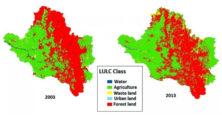
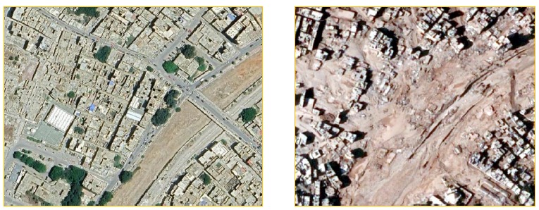
Change detection through high-resolution satellites has been transformative across a spectrum of fields. In environmental science, these satellites enable the monitoring of deforestation, a critical tool in assessing the impact of human activities on forests and biodiversity. They also play a pivotal role in tracking land cover changes, including urban expansion and agricultural encroachment, offering insights into ecosystem health and habitat loss. Additionally, high-resolution satellites are instrumental in studying the effects of climate change, as they provide precise data on shifts in temperature, precipitation, and vegetation patterns. In urban planning, these satellites assist in monitoring construction activities, infrastructure development, and urban sprawl, facilitating effective city management and disaster resilience planning. In agriculture, high-resolution imagery aids in precision farming by monitoring crop health, detecting pest infestations, and optimizing resource allocation for improved yields and sustainable practices. Moreover, in disaster management, rapid response and recovery efforts benefit immensely from the timely information provided by high-resolution satellites, allowing for the assessment of damage extent and the identification of vulnerable areas in the aftermath of natural disasters. In essence, the application of change detection through high-resolution satellites empowers various industries and scientific endeavors with invaluable insights for informed decision-making and sustainable resource management.
As technology continues to advance and high-resolution satellite data becomes more accessible, the potential for change detection will continue to grow. This powerful tool equips us with the knowledge needed to address the complex challenges of our ever-changing world, ultimately contributing to a more sustainable and resilient future. In summary, change detection, enabled by high-resolution satellite imagery, is a vital tool that empowers us to adapt and thrive in a constantly changing world. Its applications span a wide range of fields, and its significance lies in its ability to provide accurate and timely insights that drive informed decision-making. As we embrace the capabilities of high-resolution satellite imagery, we gain a deeper understanding of our planet and the changes that shape it, ultimately paving the way for a better future.