


.png)


.png)
.png)


.png)


Unveiling the World of 3D Landscapes: Creating Realism Digitally
In today’s digital age, the realm of creative possibilities knows no bounds. It’s a time when innovation and imagination harmonize to fashion real-like virtual worlds that blur the lines between fiction and reality. One such captivating realm is that of 3D landscapes, where a mere glance at the screen transports you to breathtaking natural vistas, bustling urban metropolises, or even fantastical realms—all from the comfort of your computer. Their importance spans across industries, from architectural design and environmental conservation to entertainment and education. Their fascination lies in their ability to immerse us, challenge our creativity, and push the boundaries of what we can achieve through the marriage of art and technology.
Within this complexity lies a wealth of information waiting to be unveiled, and that’s where SATPALDA Geospatial Services steps in. We are dedicated to providing 3D landscape services that unlock the secrets of our planet’s topography and composition, offering invaluable insights to our esteemed customers. We delve into the realms of DSM (Digital Surface Model) and DTM (Digital Terrain Model), offering resolutions spanning from 60cm to 10m. Our commitment to delivering tailored solutions means we provide both relative DSM/DTM (without ground control) and absolute DSM/DTM (with ground control) as per the unique requirements of our clients.
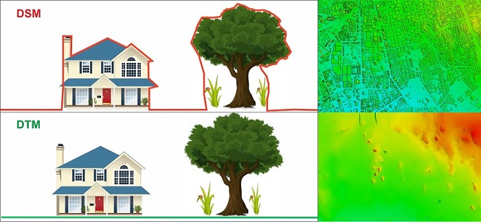
At the heart of 3D landscapes lies terrain modelling. This involves representing the varying elevations and topography of the Earth’s surface. Digital Terrain Models (DTMs) and Digital Surface Models (DSMs) provide the foundation, offering intricate details about the natural lay of the land. These models offer a dual perspective of our landscapes: DSM reveals the intricate details of structures and vegetation, while DTM uncovers the bare, natural Earth beneath, a canvas that can be crafted from a multitude of data sources, including topographic maps, high-resolution satellite imagery, radar data, and even stereo imagery captured by manned aircraft.
Digital Terrain Model (DTM)
Digital Terrain Modelling, often abbreviated as DTM, is a process that involves the creation of a digital representation of the Earth’s surface. Unlike simple elevation models, DTM provides a detailed view of terrain, including variations in elevation, slopes, and depressions. This level of detail is crucial for 3D landscape designers aiming to recreate real-world environments.
Hence, DTM plays an indispensable role in the creation of true-to-life 3D landscapes. It captures every nuance, from the gentle slopes of rolling hills to the craggy grandeur of rugged mountains. By doing so, DTM ensures that the terrain in your 3D landscape mirrors the real world with astonishing accuracy. DTM breathes life into elevation data. It allows designers to recreate natural features such as valleys, peaks, canyons, and cliffs in ways that mimic their real-world counterparts. This authenticity is what makes 3D landscapes come alive.
Environmental experts can use DTM to assess factors like slope, aspect, and drainage patterns. This data aids in diverse applications, including flood modeling, habitat assessment, and predicting erosion patterns, all of which are critical for informed decision-making and environmental preservation. Water bodies like rivers, lakes, and oceans are integral components of many 3D landscapes. DTM allows for the creation of realistic water features complete with accurate shorelines, depths, and flow dynamics. DTM, also, seamlessly integrates with 3D modelling software, making it an invaluable companion for designers. It provides a rock-solid foundation upon which 3D objects, buildings, and vegetation can be placed. This integration ensures that the created landscape is cohesive, allowing for the natural interplay of terrain and man-made elements.
Digital Surface Model (DSM)
A Digital Surface Model (DSM) represents the Earth’s surface as a grid of elevation points but includes all objects and features on the terrain. This means it encompasses both the bare terrain and the vertical extent of buildings, trees, and other objects. It includes all objects and features on the surface, such as buildings, trees, vehicles, and natural terrain variations like hills and valleys. In essence, a DSM depicts the topography of the Earth with all above-ground structures and vegetation.
DSMs are valuable in applications where you need to understand the full 3D landscape, including urban planning, forestry, agriculture, and infrastructure design. They are essential for assessing the heights of buildings, trees, and other objects on the Earth’s surface.
While, DTMs are primarily used for applications where you want to focus solely on the natural terrain, such as in contour mapping, hydrological modelling, flood risk assessment, and geological analysis. They provide a clear view of the Earth’s bare topography without any interference from man-made structures.
Conclusion
As we conclude our journey into the realm of 3D landscapes, it becomes abundantly clear that our world is far more intricate and multifaceted than a two-dimensional map could ever convey. With the introduction of the third dimension, we unlock the full depth and richness of our landscapes. Terrain modelling through Digital Surface Models (DSMs) and Digital Terrain Models (DTMs) provides us with a holistic understanding of our Earth’s surface. Buildings rise, valleys deepen, and forests sway in the wind, all in stunning three-dimensional clarity. The applications are as diverse as the landscapes themselves, spanning urban planning, environmental science, infrastructure design, agriculture, and beyond. Cutting-edge technology and advanced visualization tools enable us to navigate this 3D realm, empowering us to make informed decisions, protect our environment, and shape our world for a brighter future. Embracing the third dimension isn’t just about adding depth; it’s about gaining a deeper understanding of our world and the endless possibilities it holds.