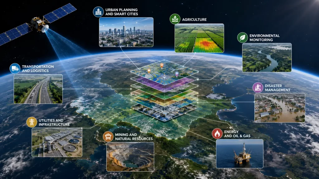
Top Applications of GIS Technology Across Industries
Geographic Information Systems (GIS) have transformed the way organizations collect, analyze, and utilize location-based data. What was once considered a specialized mapping technology has evolved into a critical decision-making tool used across government agencies, businesses, research institutions, and infrastructure organizations worldwide. Today, GIS is no longer limited to creating maps—it serves as a powerful platform for analyzing spatial relationships, identifying patterns, optimizing operations, and solving complex real-world challenges.
As the volume of geospatial data continues to grow through satellite imagery, drones, IoT devices, GPS systems, and Earth observation technologies, the importance of GIS has increased significantly. Organizations are increasingly relying on location intelligence to gain deeper insights into their operations and make data-driven decisions.
Understanding what is GIS application and how it supports various industries is essential for professionals looking to leverage the full potential of geospatial technologies. From urban development and agriculture to disaster response and environmental conservation, GIS has become an indispensable tool in the modern digital landscape.
Understanding GIS Application and Why It Matters
Before exploring industry-specific use cases, it is important to understand what a GIS application actually means.
A GIS application refers to the use of Geographic Information System technology to collect, manage, analyze, visualize, and interpret spatial data. Unlike traditional databases that organize information in rows and columns, GIS adds a geographic dimension, allowing users to understand where events occur and how different geographic factors interact.
The true value of GIS lies in its ability to integrate multiple layers of information into a single analytical environment. Population data, transportation networks, utility infrastructure, environmental conditions, satellite imagery, and demographic information can all be combined to reveal insights that would otherwise remain hidden.
Modern GIS platforms enable users to answer critical questions such as:
- Where are assets located?
- What areas are most vulnerable to risk?
- How can resources be allocated more efficiently?
- What geographic factors influence business performance?
- How will future development impact existing infrastructure?
The growing demand for spatial intelligence has made the application of geographic information system technology a fundamental component of digital transformation initiatives across numerous industries.
GIS Applications in Urban Planning and Infrastructure Development
One of the most significant uses of GIS can be found in urban planning and infrastructure management. As cities continue to expand, planners require accurate geographic information to support sustainable development and efficient resource allocation.
GIS enables urban planners to analyze land use patterns, transportation networks, population growth, zoning regulations, and public infrastructure. By visualizing these datasets spatially, planners can identify development opportunities, anticipate future demands, and minimize environmental impacts.
Transportation agencies use GIS to optimize traffic flow, identify congestion hotspots, plan new road networks, and improve public transit systems. Infrastructure developers rely on GIS to evaluate project feasibility, assess environmental constraints, and manage construction activities.
Smart city initiatives increasingly depend on GIS technology to integrate real-time data from sensors, utilities, transportation systems, and public services. This allows city administrators to monitor operations more effectively and respond quickly to emerging challenges.
As urban populations continue to grow worldwide, GIS will remain a critical tool for creating more resilient, efficient, and sustainable cities.
GIS and Its Applications in Agriculture, Environment, and Natural Resource Management
The agricultural sector has experienced a major transformation through GIS and its applications. Modern farming operations increasingly rely on geospatial technologies to improve productivity, reduce costs, and optimize resource utilization.
GIS supports precision agriculture by helping farmers analyze soil conditions, monitor crop health, manage irrigation systems, and identify areas requiring intervention. When combined with satellite imagery and remote sensing data, GIS enables continuous monitoring of agricultural fields and supports data-driven decision-making.
Environmental organizations also utilize GIS extensively for conservation and ecosystem management. Spatial analysis helps monitor forests, wetlands, biodiversity hotspots, water resources, and climate-related changes. Researchers can track environmental trends over time and identify areas requiring protection or restoration.
Natural resource management agencies use GIS to monitor mining activities, manage watersheds, assess land degradation, and support sustainable development initiatives. By integrating environmental and geographic datasets, organizations can better balance economic growth with ecological preservation.
The increasing availability of Earth observation data continues to expand GIS capabilities within environmental monitoring and resource management sectors.
GIS Applications in Disaster Management, Public Safety, and Emergency Response
Among the most impactful GIS applications are those related to disaster management and emergency response. Natural disasters such as floods, earthquakes, wildfires, landslides, and hurricanes require rapid access to accurate geographic information.
GIS helps authorities identify vulnerable areas through hazard assessments and risk mapping. By analyzing geographic conditions, population distribution, infrastructure networks, and historical disaster data, emergency planners can develop more effective preparedness strategies.
During disaster events, GIS provides real-time situational awareness by integrating satellite imagery, drone data, field reports, and sensor information. Emergency responders can quickly assess affected areas, identify evacuation routes, allocate resources, and coordinate relief operations.
Public safety agencies also rely on GIS for crime analysis, law enforcement planning, emergency medical services, and fire response operations. Geographic intelligence enables agencies to improve response times and optimize resource deployment.
As climate-related disasters become more frequent and severe, GIS will continue to play an essential role in protecting lives and reducing economic losses.
GIS Applications in Business Intelligence, Utilities, and Asset Management
Beyond government and environmental sectors, GIS has become a valuable tool for businesses seeking competitive advantages through location intelligence.
Retail companies use GIS to identify ideal store locations, analyze customer demographics, evaluate market potential, and optimize supply chain operations. Financial institutions use geographic analysis to assess risks, identify investment opportunities, and improve service delivery.
Utility companies rely heavily on GIS to manage infrastructure assets such as power lines, pipelines, telecommunications networks, and water distribution systems. GIS provides a centralized view of asset locations, maintenance schedules, and operational performance.
Organizations managing large infrastructure networks benefit significantly from GIS-based asset management systems. These systems improve maintenance planning, reduce downtime, optimize resource allocation, and support long-term infrastructure investments.
As businesses increasingly recognize the strategic value of geographic information, GIS adoption continues to expand across commercial sectors worldwide.
Conclusion
The growing importance of GIS application technology demonstrates how location intelligence has become essential for modern decision-making. From city planning and agriculture to disaster management and business operations, the application of geographic information system technology enables organizations to transform complex geographic data into actionable insights.
The diverse uses of GIS continue to expand as new data sources, advanced analytics, artificial intelligence, and Earth observation technologies become more accessible. Understanding GIS and its applications is no longer limited to geospatial professionals; it has become increasingly relevant for decision-makers across virtually every industry.
As organizations continue to embrace digital transformation and data-driven strategies, GIS will remain one of the most powerful tools available for understanding geographic relationships, optimizing operations, and solving real-world challenges.
FAQs
A GIS application refers to the use of Geographic Information System technology to collect, analyze, manage, and visualize spatial data for decision-making and problem-solving.
Major uses of GIS include urban planning, agriculture, environmental monitoring, disaster management, transportation planning, infrastructure management, and business intelligence.
GIS helps farmers monitor crop health, analyze soil conditions, optimize irrigation, manage resources, and improve agricultural productivity through precision farming techniques.
GIS provides geographic intelligence that supports hazard mapping, risk assessment, emergency response coordination, evacuation planning, and post-disaster recovery efforts.
Industries such as urban planning, utilities, agriculture, transportation, environmental management, telecommunications, defense, logistics, and retail benefit significantly from GIS technology.


