Types of Satellites: Classification, Orbits, and Remote Sensing Uses
Satellites have become an indispensable part of modern life, even though most people rarely think about them. Every day, satellites enable GPS navigation, weather forecasting, television broadcasting, internet connectivity, environmental monitoring, disaster management, and national security operations. Thousands of satellites currently orbit the Earth, continuously collecting data and supporting services that influence industries, governments, and individuals worldwide.
As the global space economy continues to expand, the number of satellites being launched into orbit is increasing rapidly. Organizations now rely on satellite technology for everything from climate monitoring and agricultural intelligence to telecommunications and defense operations. Understanding the types of satellites, their orbital characteristics, and their specific functions is essential for anyone interested in Earth observation, remote sensing, geospatial intelligence, or space technology.
While satellites may appear similar from a distance, they are designed for vastly different purposes. Their classification depends on factors such as mission objectives, orbital altitude, sensor payloads, and operational capabilities. Each category plays a unique role in helping humanity observe, understand, and interact with our planet and beyond.
Understanding the Classification of Satellite Systems
The classification of satellite systems can be approached in several ways. The most common classification methods are based on purpose, orbit, and operational function.
From a mission perspective, satellites are designed to perform specific tasks. Communication satellites facilitate data transmission across large distances, while navigation satellites provide positioning and timing services. Weather satellites monitor atmospheric conditions, and Earth observation satellites collect imagery and geospatial data about the Earth’s surface.
Scientific satellites are used to study space, planetary systems, climate processes, and cosmic phenomena. Military satellites support surveillance, reconnaissance, communications, and intelligence-gathering operations. Meanwhile, technology demonstration satellites test new systems and innovations before large-scale deployment.
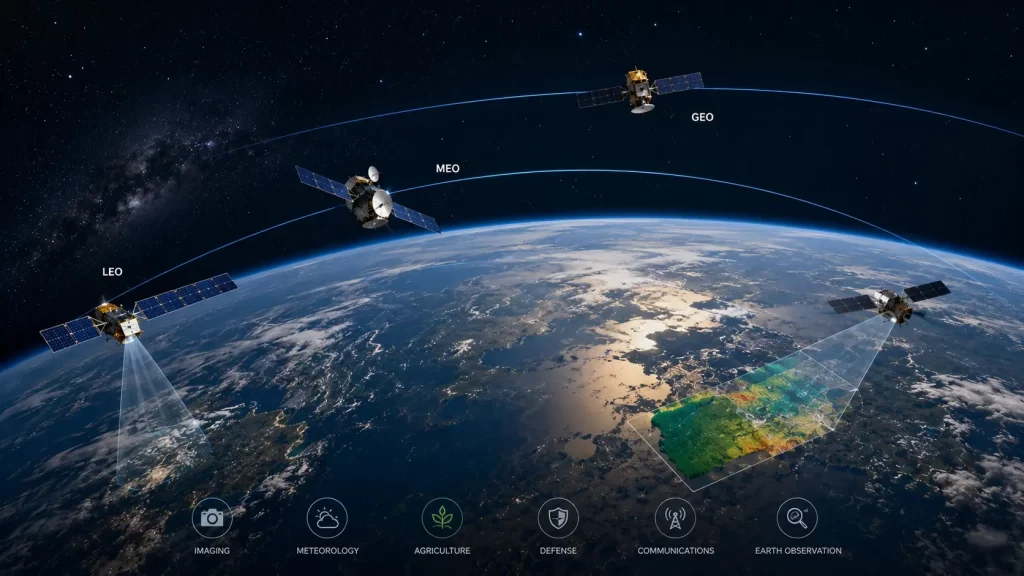
Another important method of classification focuses on orbital placement. Satellites can operate in Low Earth Orbit (LEO), Medium Earth Orbit (MEO), Geostationary Earth Orbit (GEO), or Polar Orbit depending on their mission requirements. Each orbit offers distinct advantages related to coverage, revisit frequency, communication latency, and observation capabilities.
Understanding these classifications helps explain why certain satellites are better suited for specific applications and how they contribute to modern geospatial and communication infrastructures.
Different Types of Satellites Based on Their Functions
When discussing the different types of satellites, functional classification provides the clearest understanding of their roles.
Communication Satellites
Communication satellites are responsible for transmitting television broadcasts, internet connectivity, telephone services, and data communications. They form the backbone of global telecommunications networks, particularly in remote regions where terrestrial infrastructure may be limited.
Navigation Satellites
Navigation satellites provide precise positioning, navigation, and timing services. Systems such as GPS, GLONASS, Galileo, and NavIC help users determine their location anywhere on Earth with remarkable accuracy. These satellites support transportation, logistics, surveying, aviation, and numerous consumer applications.
Weather Satellites
Weather satellites continuously monitor atmospheric conditions, cloud formations, storms, and climate patterns. Meteorological agencies rely on these satellites for weather forecasting, cyclone tracking, and climate research.
Earth Observation Satellites
Earth observation satellites collect imagery and geospatial data about the Earth’s surface. They are widely used for agriculture, disaster management, environmental monitoring, urban planning, infrastructure assessment, and defense applications.
Scientific and Research Satellites
Scientific satellites help researchers study the Earth, the Sun, planetary systems, and deep space. These missions contribute valuable knowledge to astronomy, climate science, and space exploration.
Each category serves a distinct purpose while collectively supporting critical services that modern societies depend upon every day.
Types of Satellites in Remote Sensing and Earth Observation
Among all satellite categories, the types of satellites in remote sensing have become increasingly important as demand for geospatial intelligence continues to grow.
Remote sensing satellites are specifically designed to observe and collect information about the Earth’s surface without physical contact. These satellites carry advanced sensors capable of detecting reflected and emitted energy across multiple wavelengths.
Optical satellites are the most widely recognized type of remote sensing satellite. They capture imagery similar to traditional photography and are extensively used for mapping, land-use analysis, and environmental monitoring.
Multispectral satellites collect data across several spectral bands, enabling analysts to study vegetation health, water quality, soil conditions, and environmental changes. Hyperspectral satellites provide even greater detail by capturing hundreds of narrow spectral bands, supporting mineral exploration and precision agriculture.
Synthetic Aperture Radar (SAR) satellites represent another critical category. Unlike optical sensors, SAR satellites actively emit microwave signals and can collect imagery regardless of cloud cover, weather conditions, or darkness. This capability makes SAR invaluable for disaster management, maritime surveillance, infrastructure monitoring, and defense applications.
Remote sensing satellites are increasingly integrated with artificial intelligence and advanced analytics platforms to generate actionable insights from vast amounts of Earth observation data.
Characteristics of Satellite Orbits and Their Importance
The characteristics of satellite systems are closely linked to the orbits in which they operate. A satellite’s orbit directly influences its coverage area, revisit frequency, communication performance, and observational capabilities.
Low Earth Orbit (LEO) satellites typically operate between 160 and 2,000 kilometers above the Earth’s surface. They offer high-resolution imagery, low communication latency, and frequent observations. Most modern Earth observation and remote sensing satellites operate within this orbital range.
Medium Earth Orbit (MEO) satellites are commonly used for navigation systems because they provide broad coverage while maintaining accurate positioning capabilities.
Geostationary Earth Orbit (GEO) satellites operate approximately 35,786 kilometers above the equator. Because they rotate at the same speed as the Earth, they appear stationary from the ground. This makes them ideal for communications, weather monitoring, and continuous observation of large geographic regions.
Polar orbit satellites travel over the Earth’s poles, allowing them to observe nearly every location on the planet over time. These satellites are particularly valuable for environmental monitoring, climate studies, and global mapping applications.
Selecting the appropriate orbit is a critical aspect of satellite mission design, as it determines how effectively the satellite can fulfill its intended objectives.
The Future of Satellite Technology and Remote Sensing
The satellite industry is currently experiencing unprecedented growth driven by advances in miniaturization, artificial intelligence, cloud computing, and commercial space technologies.
Small satellite constellations are dramatically increasing the frequency of Earth observations, enabling near real-time monitoring of environmental conditions, infrastructure assets, and economic activities. Commercial Earth observation companies now provide imagery updates multiple times per day, supporting industries that require timely geospatial intelligence.
Artificial intelligence is transforming how satellite data is processed and analyzed. Automated systems can identify land-use changes, monitor crop conditions, detect infrastructure developments, and assess disaster impacts much faster than traditional methods.
The future of remote sensing will likely involve greater integration between satellites, drones, IoT sensors, and geospatial analytics platforms. These interconnected technologies will create comprehensive Earth observation ecosystems capable of delivering deeper insights and supporting more informed decision-making.
As satellite capabilities continue to evolve, their role in addressing global challenges such as climate change, food security, disaster resilience, and sustainable development will become even more significant.
Conclusion
Understanding the types of satellites is essential for appreciating how modern space technology supports everyday life and critical global operations. From communication and navigation systems to advanced Earth observation missions, satellites provide invaluable services that drive innovation across industries.
The various different types of satellites are designed to fulfill specific missions, while the classification of satellite systems helps explain their unique capabilities and operational roles. In particular, the growing importance of types of satellites in remote sensing highlights the expanding role of geospatial intelligence in environmental monitoring, disaster management, agriculture, infrastructure planning, and defense.
As technology advances and new satellite constellations enter orbit, the characteristics of satellite systems will continue to evolve, unlocking new opportunities for observation, analysis, and global connectivity.
FAQs
The main types include communication satellites, navigation satellites, weather satellites, Earth observation satellites, scientific satellites, and military satellites.
Satellites are commonly classified based on their mission purpose, orbit type, operational function, and sensor capabilities.
Remote sensing primarily uses optical satellites, multispectral satellites, hyperspectral satellites, thermal satellites, and Synthetic Aperture Radar (SAR) satellites.
Satellite orbits determine coverage area, revisit frequency, communication performance, and the type of observations a satellite can perform.
Key characteristics include orbital altitude, sensor payload, coverage area, spatial resolution, revisit frequency, communication capability, and mission objectives.


