What Is GIS? A Beginner’s Guide to Geographic Information Systems
In today’s data-driven world, location has become one of the most valuable pieces of information for organizations across industries. Whether it’s finding the fastest route to a destination, monitoring crop health from satellites, planning urban infrastructure, or responding to natural disasters, geographic data plays a critical role in decision-making. This is where GIS comes into the picture. If you’ve ever wondered what is GIS, you’re not alone. Geographic Information Systems have become an essential technology for governments, businesses, researchers, and planners worldwide.
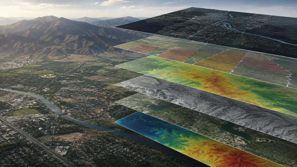
A geographic information system is a framework that enables users to collect, store, analyze, manage, and visualize data linked to specific geographic locations. By combining maps with datasets, GIS transforms raw information into actionable insights. Rather than viewing data in spreadsheets alone, GIS allows users to see patterns, relationships, and trends on interactive maps, making complex information easier to understand and act upon.
As industries continue to embrace digital transformation and geospatial technologies, understanding GIS has become increasingly important for professionals and organizations looking to leverage location intelligence.
Understanding the Fundamentals of a Geographic Information System
At its core, a GIS geographic information system integrates location data with descriptive information to provide a complete understanding of spatial relationships. Every feature represented in GIS—whether a road, building, utility line, river, or agricultural field—contains both geographic coordinates and attribute data.
For example, a city map may show the locations of hospitals. However, GIS adds another layer of information by storing details such as hospital capacity, emergency facilities, staff numbers, and service areas. This combination of spatial and attribute data enables users to conduct meaningful analyses rather than simply viewing locations on a map.
GIS systems typically consist of five major components: hardware, software, data, methods, and people. Together, these components create an ecosystem capable of handling vast amounts of geospatial information.
Modern GIS platforms can process data from numerous sources, including satellite imagery, drone surveys, GPS devices, LiDAR sensors, mobile applications, and government databases. As a result, organizations can maintain accurate and up-to-date geographic information that supports planning, operations, and strategic decision-making.
The growing availability of spatial data has transformed GIS from a specialized technology into a critical business tool used across virtually every sector of the economy.
What Is GIS Mapping and How Does It Work?
One of the most common questions asked by beginners is what is GIS mapping. Simply put, GIS mapping is the process of visualizing geographic data on digital maps to identify patterns, trends, and relationships that may not be obvious in traditional datasets.
Unlike paper maps, GIS maps are dynamic and interactive. They can contain multiple layers of information that users can turn on or off depending on their objectives. For example, a city planner might combine transportation networks, population density data, land use information, and utility infrastructure into a single GIS map to support future development projects.
The GIS mapping process generally begins with data collection. Information may come from satellite imagery, aerial photography, GPS surveys, IoT sensors, or existing databases. Once collected, the data is organized into layers representing different geographic features.
GIS software then allows users to perform various types of spatial analysis. These analyses can identify the nearest facility, determine optimal routes, measure distances, assess environmental risks, or evaluate demographic trends. The results are displayed visually through maps, dashboards, and reports that simplify complex decision-making processes.
This ability to combine multiple datasets and generate meaningful insights is what makes GIS mapping such a powerful tool for modern organizations.
What Is GIS Used For Across Different Industries?
Another frequently asked question is what is GIS used for. The answer is broad because nearly every industry today relies on geographic information in some capacity.
Urban planners use GIS to manage land use, transportation networks, zoning regulations, and infrastructure development. By visualizing growth patterns and population trends, cities can make smarter decisions about future expansion.
In agriculture, GIS supports precision farming practices by helping farmers analyze soil conditions, monitor crop health, optimize irrigation, and improve yield predictions. Satellite imagery combined with GIS analytics enables more efficient resource management across large agricultural areas.
Environmental organizations use GIS to monitor forests, wetlands, biodiversity, water resources, and climate change impacts. Spatial analysis helps identify vulnerable ecosystems and supports conservation efforts.
Emergency management agencies depend heavily on GIS during natural disasters. Flood mapping, wildfire monitoring, evacuation planning, and damage assessments all rely on geospatial intelligence generated through GIS platforms.
Transportation authorities use GIS to improve traffic management, optimize logistics operations, and plan new transportation corridors. Utility companies leverage GIS to manage pipelines, power networks, telecommunications infrastructure, and maintenance operations.
In the defense and security sector, GIS supports surveillance, mission planning, intelligence analysis, and situational awareness. The ability to analyze geographic information in real time can significantly enhance operational effectiveness.
These examples demonstrate why GIS has become one of the most versatile and impactful technologies available today.
Benefits of GIS in Modern Decision-Making
The rapid adoption of GIS across industries is driven by the substantial benefits it provides. One of the most significant advantages is improved decision-making. By visualizing data geographically, organizations gain insights that are difficult to identify through traditional analysis methods.
GIS also enhances operational efficiency. Businesses can optimize routes, allocate resources more effectively, and automate workflows using location-based intelligence. This often leads to cost savings and improved productivity.
Another major benefit is better communication. Maps are universally understood and can quickly convey complex information to stakeholders, executives, policymakers, and the public. Instead of reviewing lengthy reports, decision-makers can view spatial patterns directly on a map.
Risk management is another area where GIS excels. Organizations can identify hazards, assess vulnerabilities, and develop mitigation strategies before problems occur. Whether addressing flood risks, infrastructure failures, or environmental threats, GIS provides valuable insights that support proactive planning.
As artificial intelligence, machine learning, satellite imagery, and real-time data streams continue to evolve, GIS capabilities are expanding rapidly. Modern organizations are increasingly integrating GIS into their digital transformation strategies to unlock new opportunities and gain competitive advantages.
Conclusion
Understanding what is GIS is essential in a world where location-based data influences nearly every aspect of decision-making. A geographic information system goes far beyond simple mapping by enabling organizations to collect, analyze, and visualize spatial information in ways that drive smarter outcomes.
From urban planning and environmental monitoring to agriculture, transportation, and disaster management, GIS has become a cornerstone of modern geospatial technology. As the volume of geographic data continues to grow, GIS will play an even greater role in helping organizations transform information into actionable intelligence. For businesses and professionals seeking to harness the power of location data, GIS represents one of the most valuable technologies available today.
GIS, or Geographic Information System, is a technology that helps users collect, manage, analyze, and visualize data connected to geographic locations.
GIS mapping is the process of displaying and analyzing location-based information through interactive digital maps that contain multiple layers of data.
GIS is used for urban planning, agriculture, disaster management, environmental monitoring, transportation planning, utility management, and many other applications.
The main components of a GIS include hardware, software, geographic data, analytical methods, and skilled users who manage and interpret the information.
GIS helps organizations make data-driven decisions, improve operational efficiency, optimize resources, manage risks, and gain deeper insights from geographic information.


