What is Archive satellite Imagery? Accessing the World’s Digital Twin
Archive satellite imagery refers to historical satellite data stored in a searchable digital library. Unlike new satellite tasking, archive data is already captured and readily available as both historical and fresh archive collections. It is primarily used for change detection, allowing organizations to compare “before and after” snapshots to track construction, environmental shifts, or urban expansion.
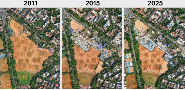
Image 1: Archive imagery timeline showcasing progressive land-use and urbandevelopment changes at the same location across 2011, 2015, and 2025.
Understanding Archive satellite Imagery
Archive satellite imagery is essentially a vast satellite imagery library that stores years—sometimes decades—of Earth observation data. Every time a satellite
captures an image of the Earth’s surface, that data is indexed, stored, and made accessible for future use.
This creates a continuously growing visual record of the planet, forming what is often referred to as a “digital twin” of the Earth over time. Instead of looking at a single snapshot, users can explore how a location has evolved across multiple time periods.
Organizations across industries rely on historical satellite data to analyze past conditions, monitor trends, and make informed decisions based on temporal insights.
Instant Access vs. Future Tasking
The biggest advantage of archive imagery is availability and efficiency. With historical and fresh archive data readily accessible, users can obtain
imagery without waiting for a satellite to revisit the location. This eliminates delays associated with new data capture (tasking), making archive imagery:
- Faster to access
- More cost-effective
- Ideal for immediate analysis
For businesses just starting with geospatial analytics, archive imagery serves as the most practical entry point. It allows them to quickly build a historical baseline of assets, infrastructure, or regions of interest.
In contrast, satellite tasking is typically used when up-to-date, highly specific imagery is required for future dates.
Enabling Change Detection Analytics
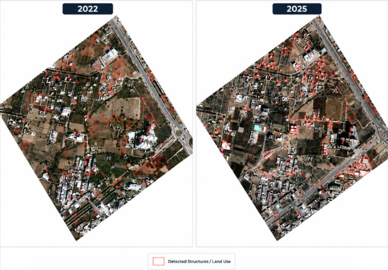
Image 2: High-resolution archive satellite imagery comparison highlighting land-use and structural changes between 2022 and 2025, with detected features outlined to visualize urban growth and development patterns.
One of the most powerful applications of archive imagery is change detection.
By layering images from different time periods, analysts—and increasingly AI models—can identify and quantify changes automatically. This process reveals patterns that are otherwise invisible in single-date imagery.
Key Use Cases:
- Urban Development Monitoring: Track how cities expand, roads develop, and infrastructure evolves over time.
- Environmental Protection: Detect deforestation, water body shrinkage, or land degradation.
- Insurance & Risk Assessment: Verify pre-event conditions (e.g., before floods or storms) using historical
records. - Agriculture Analysis: Monitor crop cycles, seasonal variations, and land-use changes.
This ability to compare past and present data transforms archive imagery into a time
machine for Earth observation.
Why Archive Imagery Matters
Archive imagery is more than just stored data—it’s a strategic asset.
It enables organizations to:
- Make data-driven decisions using historical context
- Reduce costs by leveraging existing datasets
- Detect changes with precision and speed
- Build scalable geospatial analytics workflows
Whether you’re analyzing infrastructure growth, monitoring environmental changes,or validating historical events, archive imagery provides the foundation for deeper insight.


