What is 15cm Satellite Imagery?
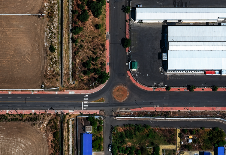
This image shows extreme ground-level detail such as vehicles, lane markings, and urban infrastructure.
Introduction
15cm satellite imagery represents the pinnacle of commercial ultra high-resolution imagery. With a sub-decimeter resolution (effectively achieved via HD processing), this imagery allows for the identification of ground features that were previously only visible through low-altitude drone surveys. It bridges the gap between traditional satellite data and aerial/drone-level detail, making it extremely valuable for modern geospatial applications.
What is Sub-Decimeter Resolution?
“Sub-decimeter” refers to any spatial resolution finer than 10 centimeters. In practical terms, it means each pixel represents less than 10 cm on the ground.
While most commercial satellites today capture imagery at around 30cm native resolution, advanced image enhancement techniques—such as super-resolution and sharpening algorithms—are used to generate a 15cm visual experience.
This is especially important for users working with ultra high-resolution satellite data, where distinguishing small objects like:
- Individual vehicles
- Road markings
- Pavement conditions
- Utility assets
is critical for analysis and decision-making.
Native vs. HD 15cm Imagery
Understanding the difference between native resolution and processed HD imagery is critical when selecting satellite data for specific applications.
| Feature | Native 15cm–30cm | HD 15cm (Processed) |
|---|---|---|
Source | Raw sensor capability | Enhanced using image processing algorithms |
Clarity | Limited by optical resolution | Improved using super-resolution techniques |
Visual Quality | Slight pixelation at high zoom | Smooth edges with sharper appearance |
Interpretation | Suitable for analysis | Ideal for visualization and mapping |
Use Case | Scientific measurements, change detection | Asset mapping, visual inspection, AI training |
HD 15cm imagery does not come directly from the sensor at that resolution but is instead created through advanced satellite data processing workflows. These include machine learning models, sharpening filters, and multi-image fusion techniques that enhance clarity and readability.
Native vs Processed Imagery Comparison
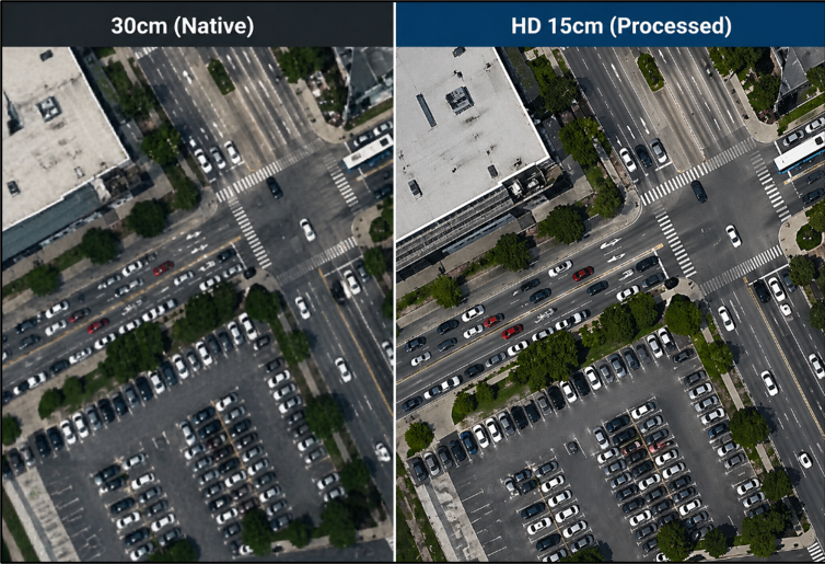
Comparison of native satellite resolution vs HD processed 15cm imagery
Conclusion
15cm satellite imagery marks a significant leap in geospatial intelligence, delivering near ground-level detail at a global scale. By combining high-quality satellite capture with advanced image processing techniques, it enables users to visualize and analyze features that were once only accessible through drone or aerial surveys.
Whether for infrastructure monitoring, urban planning, or AI-driven analysis, this level of detail enhances both accuracy and decision-making. As processing technologies continue to evolve, 15cm imagery is set to become a standard for high-precision mapping and visual interpretation across industries.
Amit Thakur
GIS Engineer


