High-Resolution Satellite Imagery: A Complete 2026 Overview
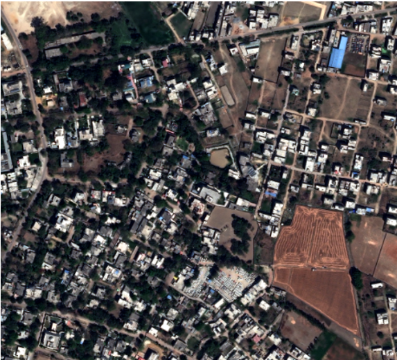
High-resolution satellite imagery is a specialized form of earth observation data captured with a Ground Sample Distance (GSD) of 50 cm or less. This level of detail is the industry standard for advanced geospatial analysis, allowing identification of specific ground assets, infrastructure changes, and environmental activity with sub-meter precision.
Types of Satellite Imagery
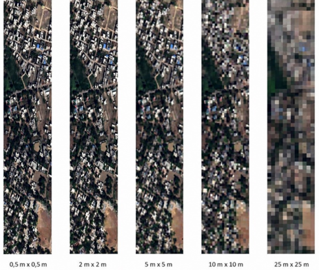
Understanding the types of satellite imagery begins with spatial resolution—the amount of ground represented by each pixel. This determines whether you can see continents, city blocks, or individual vehicles.
Low Resolution (5m+ / pixel)
Low-resolution satellite imagery is characterized by a larger pixel size, typically 5 meters or greater, where each pixel represents a broad ground area. It is best suited for large-scale environmental monitoring, regional land cover assessment, climate studies, ocean observation, and weather pattern analysis where wide-area coverage is more important than fine detail.
Use Cases:
- Large-scale deforestation tracking
- Regional drought monitoring
- Weather systems and flood spread analysis
Medium Resolution (~1m / pixel)
Medium-resolution imagery generally ranges around 1 meter to 5 meters, offering a balance between spatial detail, coverage area, and cost efficiency. It is commonly used for land-use mapping, agricultural parcel delineation, infrastructure corridor planning, forestry analysis, and periodic change detection across districts or regions.
Use Cases:
- General land-use classification
- Agricultural parcel boundary mapping
- Transportation corridor planning
High Resolution (≤50cm / pixel)
High-resolution satellite imagery typically refers to data with 50 cm or finer pixel size, enabling precise visualization of individual buildings, roads, vehicles, utility assets, and small surface features. It is widely used for urban planning, defense intelligence, precision mapping, construction monitoring, cadastral applications, and advanced geospatial analytics.
Use Cases:
- Critical infrastructure monitoring
- Urban planning and zoning enforcement
- Security and tactical intelligence
- Construction progress tracking
Defining Ground Sample Distance (GSD)
Ground Sample Distance (GSD) is the distance between the centres of two adjacent pixels as measured on the ground. In simple terms, it tells you how much real-world area one pixel represents.
If a satellite has a 30 cm GSD, one pixel equals a 30 cm × 30 cm area on Earth.
Common Commercial GSD Benchmarks
- 15 cm GSD – Highest commercial detail; captures lane markings, small equipment, compact assets.
- 30 cm GSD – Industry standard for precision mapping, urban analysis, and property assessment.
- 50 cm GSD – Strong balance of coverage and clarity for utilities, logistics, and corridor monitoring.
How High-Resolution Data is Captured
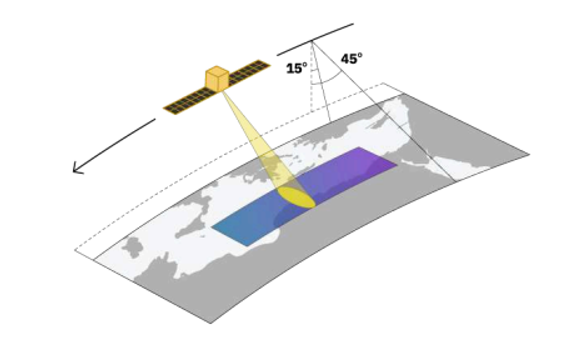
High-resolution imagery is acquired through advanced earth observation satellites equipped with sophisticated optical sensors.
Most commercial systems operate in sun-synchronous orbit, meaning they pass over the same location at nearly the same local solar time each day. This ensures:
- Consistent lighting conditions
- Comparable shadows across dates
- Reliable change detection
- Better multi-temporal analytics
These satellites scan the surface using sensor arrays, capturing narrow strips called swaths as they move along their ground track.
Business Value – From Raw Data to Insights
The real power of imagery begins when raw pixels are transformed through satellite data analytics into decisions, forecasts, and measurable outcomes.
Mining
- Monitor tailings dam deformation
- Estimate stockpile volumes
- Detect haul road expansion and site activity
Agriculture
- Variable-rate nitrogen application using vegetation metrics
- Crop stress detection before visible damage
- Field boundary intelligence for farm management
Urban Planning
- Mapping illegal construction
- Updating base maps faster than field surveys
- Optimizing road, drainage, and utility routes
Energy & Utilities
- Pipeline and transmission corridor monitoring
- Encroachment detection
- Vegetation risk assessment near assets
Conclusion
High-resolution satellite imagery has evolved into a critical decision-support resource, enabling organizations to observe the Earth with exceptional spatial detail, speed, and consistency. From infrastructure monitoring and precision agriculture to urban development and environmental intelligence, sub-meter imagery transforms raw pixels into measurable operational value. As revisit frequency improves, analytics become more automated, and delivery shifts to cloud-based platforms, high-resolution satellite data is no longer just imagery—it is a strategic asset for faster decisions, smarter planning, and scalable geospatial insight.
Sanchita Maitri
GIS Engineer


